
EkranoYacht: A Hydrogen-Powered Flying Yacht
We may collect a share of sales from items linked to on this page. Learn more .
Every once in a while, an eco-friendly concept vehicle comes around that is either too crazy, or too cool, to not post about. In the EkranoYacht, we have a bit of both.
What Is It?
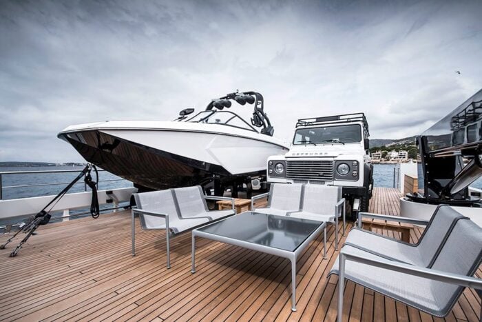
Not only is this concept vehicle straight out of a futuristic Jetsons-era world, but its designer has actually come up with specs on the boat’s size and speed. Estimated to be 118 feet long, and travel at top speeds of 250 mph, this flying yacht will be able to hold six passengers, fly 4 m above the water, and still produce no emissions except for a bit of water vapour and hydrogen.
Is a Flying Yacht Possible?
One of the craziest things about this concept vehicle is it is based mostly in the real world. According to gas2.org , a similar vehicle was created in the former Soviet Union, and despite its weight of 550 tons was able to fly 66 feet above the water at up to 460 mph. The vehicle was called the Ekranoplan and could “fly” because of the high-pressure air created by “the aerodynamic contact between the wings and the water’s surface”.
Are you surprised you are just hearing about this now? It’s probably because they are insanely expensive to make, and people mostly forgot about them after the collapse of the Soviet Union. But now, the EkranoYacht’s creator, Australian designer Jaron Dickson, has plans to bring the technology back to life with an eco-friendly twist.
When Can I Get One?
The short answer is, by the time you can have one you won’t care about it anymore. Even if this thing does make it to market (which is currently slated for 2025), who knows what other crazy technology we will have by then that will dwarf the simple EkranoYacht hydrogen engine. Until then, it’s at least an enjoyable fantasy to keep in mind for the future.
Check out more pictures of the eco-friendly concept watercraft at the Australian Design Awards
As the Co-founder and Editor-in-Chief of Greener Ideal, Ian has been a driving force in environmental journalism and sustainable lifestyle advocacy since 2008. With over a decade of dedicated involvement in environmental matters, Ian has established himself as a respected expert in the field. Under his leadership, Greener Ideal has consistently delivered independent news and insightful content that empowers readers to engage with and understand pressing environmental issues. Ian’s expertise extends beyond editorial leadership; his hands-on experience in exploring and implementing sustainable practices equips him with practical knowledge that resonates with both industry professionals and eco-conscious audiences. This blend of direct involvement and editorial oversight has positioned Ian as a credible and authoritative voice in environmental journalism and sustainable living.
View all posts
What do you think? Leave a comment! Cancel reply

Green Hydrogen: A Sustainable Alternative Fuel

What Are the Unique Benefits of Hydrogen Fuel for Transportation?

Can Hydrogen Cars Still Power the Future of Sustainable Transportation?
Popular today.

How Technological Advancements Are Shaping Environmental Health and Safety in 2024

5 Surprising Ways Ocean Pollution Affects Human Health

4 Signs of Battery Degradation in Your Electric Car
Greener Ideal helps you live in more sustainable ways with green living tips, commentary on the latest environment news, green product reviews, healthy recipes, and more.
We strive to protect the planet and reduce our collective carbon footprint.

The Importance of Knowing the Origin of Your Ingredients

Bridging Convenience with Sustainability in Modern Diets

8 Insta Tofu Recipes That Will Melt Your Tastebuds

The Environmental Impact of Disposable Tooth Flossing Picks: Time to Consider Sustainable Alternatives

The Rural Shift: Balancing Sustainability in Country Living

Can Regular Air Quality Checks Lead to Energy Savings?
© Copyright 2024 - Greener Ideal
Aquila Global Is Bringing Back the Ekranoplan With Its Boat-Aircraft Hybrid Vehicle
Its 12-seater ground effect vehicle will be flying next year.
:max_bytes(150000):strip_icc():format(webp)/Lloyd-Alter-bw-883700895c6844cf9127ab9289968e93.jpg "ekrano yacht")
- University of Toronto
Katherine Martinko is an expert in sustainable living. She holds a degree in English Literature and History from the University of Toronto.
:max_bytes(150000):strip_icc():format(webp)/Katherine-Martinko-bw-ae5224ea084d4d9c8acb22e51074339f.jpg "ekrano yacht")
Aquila Global
- Environment
- Business & Policy
- Home & Design
- Current Events
- Treehugger Voices
- News Archive
After writing the post " Bring Back the Ekranoplan ," praising the wonderful former Soviet Union ground effect vehicles, I was contacted by Aquila Global co-founder Timour Maslennikov, who said his company is bringing them back with the Aquila Global AG12 . It is what he calls wing-in-ground effect (WIG) crafts, saying it is "a re-emerging technology that provides surface transportation over water with shared characteristics of both air and marine crafts in terms of speed and payload capacity, but with much lower operating costs and maintenance."
The vehicle glides between 3 and 10 feet above the water, and if it is rough it can fly at altitudes of up to 500 feet. It can fly at speeds comparable to a plane between 50 and 350 miles, but since WIGs are recognized as maritime vessels, I could drive it with my boat license. It seats 12, yet has an empty weight of only 5,720 pounds—I suspect mostly engines.
It's powered by two V12 gasoline or diesel engines ; you can pull them out of a Chevy Camaro SS at 430 horsepower each, or pump it up to 1,000 horsepower with custom engines. Maslennikov says: "It will zoom a few feet above water at a top speed of 250 mph on regular car gas. The optimal cruise speed is between 130-150 mph on 15-18 gph, depending on the vehicle loading. Within operating envelope it can cover 1200+ miles in 5 hours on 100 gallons of pump gas."
The comparisons to other forms of transport are surprising. It is ten times as fast as a boat, it gets 18 miles to the gallon using regular fuel, and costs a fraction to operate compared to planes or helicopters. "More bang for your buck—no FAA [Federal Aviation Administration] oversight, no need for specially certified mechanics to perform maintenance, no need for expensive insurance," says Maslennikov. "Also, there is no need for any infrastructure, you can operate shore-to-shore from the beaches."
I had a pile of questions about ekranoplans, in general, and about Aquila Global, in particular, and Maslennikov was kind enough to respond. I have edited our interview a bit for brevity.
Treehugger: I am surprised that one doesn't need a pilot's license, that I could pilot this with my Canada and Toronto marine operator licenses! Can something that can go to 500 feet really be considered a boat?
Timour Maslennikov: Well, this one has a few caveats. In general, there are 3 types of ground effect vehicles, aka GuVs or Ekranoplans, Class A, B & C. As of now most of the ekranoplans within Class A & B are considered vessels according to the Maritime Rules, so they do not have to abide by the FAA requirements. The Class C vehicles is another story, which I’ll explain below.
Class A cannot really go that high over the surface of the water during normal operations. The configuration of these machines limits them to be operated only in the ground effect and only within a foot from the surface, like the Aquaglide in the video. These machines are mostly used as small personal recreational/fun vessels, carrying 1-4 people.
The class B machines are configured to temporarily lift itself out of the ground effect into the altitudes of no more than 150 meters/500 feet AGL (above ground [sea in our case] level). The altitude limitations is pretty much what separates these vehicles from the aircraft's classification according to the current Maritime rules and limitations.
Ekranoplans are extremely efficient when operated in the ground effect, i.e. close to the surface. They have the ability to transport more cargo by weight when compared to similar-sized aircraft. However, when class B machines are lifted higher into the air, their efficiency decreases dramatically, and they become less efficient than a conventional aircraft of a similar size. Therefore, I suppose in the future, operators would be lifting their machines into an altitude of 20-50 meters [66-164 feet], or even higher, only to jump over sandbanks, islands with tall vegetation, without bothering to change the course, or to avoid rough seas/large waves in the adverse weather conditions. There are really no economic incentives to operate constantly above 10-15 meters [33-50 feet] all the time during the calm weather, at the cost of burning more fuel than they would have to as during the normal operating conditions.
A good example of class B machines would be Russian Orion 14. The manufacturing rights of this machine, for example, which was originally developed in Russia, were sold to China. Right now it is being duplicated under designation CYG-11, however, it has a number of things that can be further improved.
Technically, class C machines are called Ekranolets (the “let” portion refers to “samolet”, which is an aircraft in Russian) and they are basically designed and built as an aircraft but with some ekranoplan capabilities. In other words, it’s a somewhat mediocre aircraft and probably a way too sophisticated and expensive ekranoplan. These machines can be operated at higher than 150m/500 ft AGL altitudes, but they must follow all FAA regulations in manufacturing, operating, insurance, and maintenance phases.
In the specifications, it says the ground effect is only between 2 to 12 feet which doesn't seem like much for even regular seas in open water. Will that limit its utility or am I wrong about common wave conditions in, say, the Caribbean between islands? If you have a five-foot swell, does it fly level or does it follow the swell?
It really depends on the type of ekranoplans being used and its size. For example, if someone brave enough decides to use a small-sized Class A machine like AquaGlide to cross Atlantic Ocean, let’s say, from Miami to Cuba, they’d definitely experience a spectacular crash into the swells and sink probably pretty much instantaneously. If that would be a larger machine, let’s say Lun-class ekranoplan or Orlyonok or any sized Class B machines, those can easily travel well above the large swells, provided they were able to take off in a bay or a somewhat protected water strip with a smaller swell. The landing part is less critical because swells are usually moving/pushing vehicles into the shore.
It should be mentioned that ekranoplans are not 100% all-weather vehicles, just like boats and aircraft they are not useful during serious storms. However, unlike boats, when they are already en route, these machines have enough speed to go around the slow-moving adverse weather conditions, just by simply changing the course and avoiding it altogether.
The economics of this are amazing, 18 miles per gallon, better than an SUV. That is a huge environmental benefit right there. But I am wondering, since there are a few small planes running on electric motors, could this be electrified?
As far as electrifying ekranoplans, I wish it was the case. It would make building ekranoplans so much easier.
As far as battery energy density, the best technology can squeeze only about 200Wh per kilo of battery weight. These above-mentioned batteries are high-risk Li-Ion, they are not even the latest LiFePo4. The latest LiFePo4 batteries can hold even less energy, only 80-120Wh/kg. This plays a major factor in underperforming electric aircraft and eVTOLs [electric vertical take-off and landing aircraft], with such low energy density batteries they can only operate on average for 45-60 minutes.
Now, the same weight of gasoline has an energy density of 12,000Wh/kg. If you factor all of the inefficiencies of the internal combusting engine, the gas engine would still outperform electric batteries by 6 times. In the end, a 100 kilo of gasoline refueling can take an ekranoplan on a 5.5hr journey and cover about 1200 miles. Electric variant, not so much.
As far as battery weight, it stays static regardless of whether the battery is discharged or fully charged. The electric vehicle has to lug these heavy batteries whether the operator likes it or not. As a result, one of the factors that extends distance traveled in the conventionally powered ekranoplan is an emptying fuel tank.
Are we running away from electric vehicles? Not at all, this technology would be highly desirable when decent batteries are developed. I’ve always said in the past, it’s relatively easy to manufacture an electric motor that can deliver hundreds of horsepower from the batteries. The main problem is the batteries.
Because it is not actually an airplane, do you get to skip the years of certification and all that FAA stuff?
That is correct. We have nothing to do with FAA, our product is in essence a fancy fast-moving boat. The boat certifications, although desirable, are not mandatory. Nevertheless, we will undertake a full range of product testing, documentation, changes, and sea trials before rolling the product out to the customers. During the manufacturing stage of the initial vehicle, we will also work with a marine insurance company to address concerns and to understand the process of potentially certifying ekranoplans under Maritime rules, if that would be necessary.
When asked when it would be flying, Maslennikov said the pandemic threw a wrench into the product development schedule. He noted: "I would estimate that the first ekranoplan will be tested by the end of 2023."
In our previous post, I called ekranoplans "pie in the sky." Although the AG12 ekranoplan isn't flying yet, you can order one now and probably get it in two years. And maybe someday we will get those light batteries and be able to flight an ekranoplan electrically.
- Air Canada Electrifies Its Lineup With Hybrid Planes
- Are Modernized Ground Effect Vehicles the Answer to Greener Flying?
- Fly Better Electrically in the Airlander 10
- Flying Private Is Taking Off Due to Pandemic and Airport Pandemonium
- FlyZero's Zero Carbon Plane Spotlights the Mixed Blessings of Visionary Concepts
- Boom! Supersonic Passenger Planes May Return to the Skies
- Rolls-Royce's All-Electric Plane Takes Its First Flight
- Why Big Electric Planes Won't Fly, According to Vaclav Smil
- Hydrogen-Fueled Planes Could Meet One-Third of Air Travel Demands by 2050
- Airbus Proposes Planes Fueled by Liquid Hydrogen
- Why Are European Airlines Flying So Many Empty 'Ghost Flights'?
- New Site Tracks Emissions From the World’s Largest Airports
- American Airlines Orders 20 Supersonic Jets—Is It Really Sustainable?
- UK Cuts Tax on Domestic Flights Ahead of COP26
- Small Electric Planes Could Help Decarbonize Air Transportation
- Majority of World's Flights Taken by a Small Minority of Elite Travelers

- Search See all results

Confidence and Empowerment Through Facial Reconstruction
Is a Support Yacht in Your Future?

What’s New This Spring? Remodeling Trends Focus On Where Appeal Meets Durability
Ekrano yacht concept by jaron dickson.

Why Remote Work Can Improve Your Business

Subscribe Now
- The Australian Plus benefits
- The Australian app
- Newsletters
- My comments
- Saved stories
New super-yacht the Ekranoyacht 'will fly'
AUSSIE designer reveals plans for a super-yacht that can fly four metres above the water at speeds of up to 400 km/h.

AN Australian designer has revealed plans for a yacht that can fly four metres above the water at speeds of up to 400 km/h.
One of the entries for the Australian Design Award 2011, the Ekranoyacht design aims to “bring the super car flavour to the water”.
Designed and named after the famous Soviet Union super vehicle the Ekranoplan, the futuristic yacht is planned for 2025.
Designer Jaron Dickson, 23, from Monash University in Melbourne said that the concept is focussed on more efficient sea travel and protecting the environment.
The 35.6 metre craft will use hydrogen power and fly above the water surface at speeds of approximately 400 km/h.
It will be able to tackle waves of up to 3.5 metres and it also has an electric motor so that it can also be used as a regular yacht when moving through certain coastal areas.
The yacht will be able to accommodate six guests and will have an open floor living plan, with large windows for natural light.
“Humans are always thinking of new ways travel and improve their dynamic lives… My project has the liveability of a yacht and the convenience of an aeroplane,” Mr Dickson said.
The Ekranoplan was a half-plane half-boat vehicle conceived by the Soviets that could skate along the water.
Known as the “Caspian Sea Monster”, it used the ground effect - also known as the wing-in-ground-effect - where a cushion of high-pressure air is created by the aerodynamic contact between the wings and the water's surface.
Smaller versions of this craft was used to transport troops and vehicles in the Black and Caspian seas until the collapse of the Soviet Union.
Add your comment to this story
To join the conversation, please log in. Don't have an account? Register
Join the conversation, you are commenting as Logout
Star spotting on holiday
MOST travellers have a tale of meeting someone famous on a trip, and they can make for great anecdotes when you get back home.
Body scanners ‘highly inaccurate’
THE devices returned false results 54 per cent of the time during trial at German airport, triggered by folds in clothing and even sweat.
Russia’s Flying Sea Monster Broke Free
Neither plane nor boat, the Ekranoplan once launched nuclear-tipped missiles. Now, after a towing gone wrong, it's stranded off a beach.

- The Soviet Union was the only country to experiment with such a craft, and Russia abandoned the effort after the Cold War.
- The last known Ekranoplan is now stuck in shallow water off the coast of the Caspian Sea.
One of the most unusual vehicles of the Cold War—or any time, for that matter—is sitting abandoned on a beach in Russia. The Ekranoplan, a plane-boat hybrid craft that rode a cushion of air just above the surface of the water, was being towed across the Caspian Sea when it broke free and ended up stranded within wading distance of a local beach.
✈ You like badass planes and boats. So do we. Let's nerd out over them together.
The Ekranoplan was the Soviet Union's attempt to build a craft capable of exploiting the wing in ground effect (WIG). As an aircraft flies closer to the ground, air pressure builds between the wing and the flat surface below. This creates a cushion of air beneath the plane. Meanwhile, the low altitude eliminates wingtip vortices, decreasing drag.
During the Cold War, the Soviet Union developed large, turbojet-powered craft that used the WIG effect to “fly” above the wavetops. The Soviets designed the Lun-class WIG craft to use the effect to float just inches over the surface of a lake or ocean, adding eight forward-mounted turbojet engines to give them a top speed of 373 miles per hour.

This super low altitude ensured they were below the radar horizon of enemy warships until the ships were within range of the Lun’s six SS-N-22 “Sunburn” missiles. A Mach 3 sea-skimming missile, the Sunburn had a range of 64 miles, flew from 16 to 32 feet above the surface of the water, and could pack a nuclear warhead. This made them capable of sinking the largest ships, including U.S. Navy aircraft carriers.
Today, the Ekranoplan–the only Lun ever built—lies stranded off a beach in the Caspian Sea. This summer, the craft was in the process of being towed from a nearby naval base to a museum when something appeared to have gone terribly wrong. Instead of making it to its new home, the Ekranoplan ended up stranded in shallow water, where it's drawing visitors.
Forbes reports the ship is stranded in the surf line and taking on water. Locals have tried to pull it ashore to no avail. One urban explorer, Lana Sator , flew from Moscow to Dagestan to photograph the craft’s interior. After wading out to the Ekranoplan and evading a security guard, Sator and her companion took several photos of the interior, as seen here .
It’s not clear this one-of-a-kind ship (or aircraft) will ever make it to its museum. As H.L. Sutton of Forbes writes, “it will be a tragedy for military history if this unique craft is broken into pieces by the powers of nature.”

Kyle Mizokami is a writer on defense and security issues and has been at Popular Mechanics since 2015. If it involves explosions or projectiles, he's generally in favor of it. Kyle’s articles have appeared at The Daily Beast, U.S. Naval Institute News, The Diplomat, Foreign Policy, Combat Aircraft Monthly, VICE News , and others. He lives in San Francisco.

.css-cuqpxl:before{padding-right:0.3125rem;content:'//';display:inline;} Military Aviation .css-xtujxj:before{padding-left:0.3125rem;content:'//';display:inline;}

China's H-6 Bomber To Play Vital Role in Air Force

It’s Hot Bomber Summer in Alaska

The Army is Building the Next Tiltrotor Aircraft

First F-16s Arrive in Ukraine

A WWII Vet’s Wild Ride on Top of an Airplane Tail

‘Bomber Raptor’ Concept Looks Like the Future

Houthi Drone Strike Rocks Israel

America's Last Zuni Rockets Have Been Deployed

Air Force Building Missiles That Don't Need GPS

Will NGAD Ever Actually Fly?

The Newest X-Plane is a Quiet, Stealthy Spy Plane

Levitating Ships

The Future is Here with the Flying EkranoYacht


Brittany Ferries are planning to use an ekranoplan on the English Channel

Brittany Ferries intend to use a Ground Effect Vehicle (GEV) – what the Russians called an “ekranoplan” when they developed the concept in the 1960s – on some cross channel routes.
The ferry operator has announced that it is exploring the potential for a new sustainable version of the GEV, which they are calling a seaglider , in partnership with REGENT (Regional Electric Ground Effect Nautical Transport) in Boston, USA. The all-electric seaglider will offer a high speed passenger service on medium-to-short sea crossings.

Brittany Ferries has signed a letter of intent which could see seagliders with a 50-150 passenger capacity sailing between the UK and France by 2028.
GEV s* work by harnessing a concept well-known to pilots since the earliest days of aviation – ground effect. This is the cushion created by high-pressure air trapped between wings and the ground or water while flying at low altitude, typically one to ten metres above the surface.

The world first realised the practical capabilities of GEVs when U.S. intelligence satellites caught sight of the Soviet Union’s enormous (92m) top secret research ekranoplan shooting across the surface of the Caspian Sea at speeds over 300 knots (555 kph/345 mph) in the early 60s! They dubbed it the ‘Caspian Sea monster’. Quite right! Two decades later it had been developed into the nuclear missile carrying Lun-class ship killer.
The only Lun-class ekranoplan broke free while being towed to a new museum in Derbent, Daghestan in August 2020. While beached, a resourceful photographer managed to slip on board .
Brittany Ferries’ seaglider is rather more benign. It is expected to fly passengers gently at speeds of up to 180 mph – six times faster than conventional ferries – with a battery-powered range of 180 miles.
The voyage (it is a “voyage”. The International Maritime Organization classified GEVs as ships in 2005) from Portsmouth to Cherbourg, for example, could be covered in as little as 40 minutes.
The seaglider design uses hydrofoils to cushion the jarring impact of waves as it gathers speed before taking off, and on landing.
Once airborne it is a highly efficient form of transport, capable of moving significant loads over long distances at high speed.
One of the issues that has effected GEVs in the past has been safety at speed. At such high speeds it is really important to detect ships and other obstacles early. The seaglider comes with next-generation sensor suites detecting and automatically avoiding traffic at sea.
Both Brittany Ferries and REGENT understand that many technological, practical and regulatory milestones lie ahead. However, both companies say that caution should not stand as an impediment to the development of a promising concept that already has a history in military applications and smaller leisure craft operating around the world.
“This could be the birth of ferries that fly across the Channel,” notes Frédéric Pouget, ports and operations director for Brittany Ferries. “We are particularly pleased to contribute now because it means we can bring real-world challenges and potential applications into the company’s thinking at an early stage. We hope this may help bring commercial success in the years that follow.”
UPDATE (20/10/2022) : Another ferry company has ordered seagliders from REGENT. FRS (Förde Reederei Seetouristik) , a German ferry operator that has a large fleet of ships from small passenger ferries in Berlin to large Ro-Ro ferries carrying passengers & freight across the Straits of Gibraltar, in the Pacific Northwest and in Oman, has signed an agreement for two seaglider models – the Viceroy seaglider , carrying up to 12 passengers and the Monarch seaglider , which will hold up to 100 passengers.
* Sometimes also referred to as WIGs (Wing In Ground effect)
- ground-effect
Related Stories
You may like this, review: london transport museum.

Urban Aerial Taxi cleared to fly during the Paris Olympics

New ‘Jolly Roger’ display at the Submarine Museum, Gosport

DIY Road Traffic Monitoring for Citizens

New Photo Exhibition of Underground Stations being used as Bomb Shelters – Then and Now

Join the Conversation →
Leave a reply cancel reply.
Your email address will not be published. Required fields are marked *
This site uses Akismet to reduce spam. Learn how your comment data is processed .
This is a niche blog about technically-minded travel. It reflects my own interests in the mechanical, technical, historical, engineering, transport and military world.
COPYRIGHT © MECHTRAVELLER 2016-2024, including all images unless indicated otherwise.
The most comprehensive and authoritative history site on the Internet.
“Ekranoplan,” the Soviet Union’s Flying Ships
Russian dreams of gigantic ground-effect planes are dead in the water.
The story of modern transportation is littered with vehicles that were supposed to be game-changers but that invariably became yet more deposits in the dustbin of history. Maglev trains, monorails, superblimps, Segways, jetpacks, hovercraft, hydrofoils, skycycles, flying cars… the list goes on. One of the strangest was a half-ship, half-airplane Soviet specialty called the ekranoplan—Russian for “ground-effect plane.” (The past tense is intentional; though there are still small ekranoplans being built by entrepreneurs and enthusiasts, and perennial proposals for ekranoplans the size of Poughkeepsie that never get any further than the pages of Popular Science , the concept is essentially, shall we say, dead in the water.)
Ekranoplans—also called WIG vehicles, for wing in ground effect—were exactly that: airplanes that flew in ground effect. Well, maybe not exactly that. Some would say that ekranoplans were not airplanes but ships that skimmed above the sea. It is perhaps telling that many photographs of cruising ekranoplans show them no farther out of the water than an unlimited hydroplane racer riding its prop. Like any well-developed bureaucracy, the Soviets wasted lots of time arguing about whether they should be developed by shipyards or aircraft companies, flown by pilots or driven by mariners, or be subject to aviation or maritime rules.
Though a Finnish engineer flew a twinengine ekranoplan in 1935 and the Soviets began to seriously develop the concept in the early 1960s, the world’s first big ekrano was actually American: Howard Hughes’ infamous eight-engine “Spruce Goose” flying boat, which flew only in ground effect, just as ekranoplans eventually would. Had that been Hughes’ intent, the H-4 Hercules might have gone on to become a successful wave-skimmer, making regular runs to Honolulu, rather than the Edsel of airplanes.
Many ekranoplan designers were actually wrong about why their quasi-airplanes flew. Until recently, generations of commercial and military ground school instructors had told their students that ground effect was created by a “cushion of air” under an airplane’s wings when it was flying close to the ground or water at a distance typically equal to half its wingspan, and the ekranoplan developers knew no better. Some still don’t. It made sense that a wing close to the ground would somehow trap a swirl of air to buoy the airplane, but it was a myth.
A harmless one, though. In the words of aircraft designer-builder and writer Peter Garrison, “Like creation myths, it offered a simple, easily memorized way to get people to stop asking unanswerable questions.” For ground effect is a complex, difficult-to-explain phenomenon best left to textbooks. And like creation myths, it is best accepted on faith. Suffice it to say that an airplane flying very close to water (or level ground, such as a runway) experiences less induced drag. The downwash angle is reduced, and this rotates the lift vector forward, thus allowing an aircraft to stay aloft using less power and less fuel (or, to put it another way, carrying more weight than it could otherwise lift outside of ground effect).
Ekranoplans certainly worked, after a fashion. The Soviet Union was blessed with several enormous bodies of water, both lakes and seas—the Caspian, Black, Baltic and Barents seas and Lake Baikal, primarily—which served as either test sites or potential operating zones for enormous cargo-, passenger-or troop-carrying ground-effect vehicles.
And enormous they were. The Soviets went straight from building small proof-of-concept vehicles to impossibly huge sea skimmers. It was as though Boeing (which itself briefly dallied with an enormous ekranoplan heavy-lifter concept called the Pelican) had looked at a Piper Cherokee and said, “Guys, I think we could scale this way up, put a bunch of turbofans on it, double-deck it and carry 1,000 passengers.”
The Soviets always had a thing for mine’s bigger-than-yours aerial gigantism. Igor Sikorsky’s 1913 Ilya Muromets was so large that crewmen strolled atop the fuselage in flight. The enormous Tupolev ANT-20 Maxim Gorky, horribly wrecked by a stunt-flying fighter over Moscow in 1935, was the biggest landplane of its time. Today’s six-engine Antonov An-225, at 1,323,000 pounds the heaviest airplane ever to fly, makes welterweights of Lockheed C-5s and double-deck Airbus A380s.
So it’s no surprise that the Soviets, and today the Russians, have been attracted to the possibilities offered by flying ships. Beriev, the company that has designed and manufactured the world’s most advanced flying boats and amphibians, started experimenting with WIG vehicles in the early 1960s. However, its only full-size, manned ekranoplan—a singleseat turbojet that was designed to use hydrofoils to lift it to a takeoff stance—never was able to achieve ground-effect flight.
Yet this hasn’t prevented Beriev from proposing WIGs so big they’d make Boeing blush. The 12-turbofan Beriev Be-2500 cargolifter, a scale model of which was unveiled at an aviation exposition in September 2000, would weigh 2,500 metric tons (2,750 U.S. tons). But wait, there’s more: The proposed Be-5000—yes, 5,000 metric tons—would have 23 engines and weigh more than eight times as much as the An-225.
Actually, very few true ekranoplans were ever built by the Soviets—perhaps 30, including small prototypes and proof-of-concept vehicles. The most impressive was the 10-jet, 550-ton KM, the so-called “Caspian Sea Monster,” which, legend has it, put the wind up the CIA when satellite surveillance showed the squat-winged, neither fish nor fowl giant under construction in the mid-1960s. The Monster today sits derelict at its Caspian Sea docking facility. The amphibious Orlyonok (Russian for eaglet), with wheels for beach assaults, was a high-speed transport with an enormous contrarotating turboprop atop its T-tail; only four ever flew, and just one survives, outside a Moscow museum. Scariest of all was the 400-ton Lun (harrier), which carried six big anti-ship missiles in launch tubes on its back; only one was built, and it too is “in storage,” essentially abandoned outdoors.

In any collection of ekranoplan photographs and illustrations, the two phrases most frequently seen in captions are “artist’s impression” and “computer-generated image.” Fevered dreams and fertile imagination have lifted far more ekranos than ground effect ever did. Many of those photos are of fancy scale models on display at airshows. Sometimes the models are of existing ekranoplans, for one ekrano problem is that if they are built on a lake or inland sea, they are pretty much trapped there forever, short of substantial disassembly for barging or trucking to a new site. Imagine building a guided-missile cruiser on the Lake of the Ozarks and then needing it for action in the Persian Gulf.
Ekranoplans can fly in ground effect over land as well as water, technically, but at 250 or 300 mph, you wouldn’t want to do it over anything but an enormous desert or a trackless prairie. And to make the concept even more confusing, the Soviets set out to develop three categories of ekranos: Type A, which could cruise only in pure ground effect; Type B, which could maintain flight out of ground effect to altitudes of perhaps 500 feet; and Type C, which supposedly could fly at thousands of feet above ground level, like a conventional airplane. (Type Cs were only proposed, never built.)
At any altitude, ekranoplans made lousy airplanes. Relatively stable longitudinally while flying very close to the water but less stable in roll, they became wallowing monstrosities, according to at least some experienced Soviet test pilots brave enough to speak their minds, when out of ground effect.
Obviously, a sophisticated, WIG-specific autopilot was needed for such situations. So ekranoplan developers, officially part of the navy’s hydrofoil-design department, asked their aviation counterparts for help. “Nonsense,” said the fly-guy bureaucrats. “Soviet aviation regulations make it illegal to use an autopilot at any altitude under 500 meters [about 1,600 feet], so there’s no point in pursuing such development.”
The promoters of enormous commercial ekranoplans eventually seemed to realize that yes, they were moderately fast, but they really didn’t have that big a payload per unit of horsepower, particularly compared to surface vessels. Proponents of military ekranoplans that would sneak across oceans under the radar to fire off missiles or land troops must have decided that radar was so 1970s, and that satellite surveillance would pick off huge, loping ekrano fleets as soon as they cast off their moorings. Tactically, ekranoplans would have been useless, able like a ship to maneuver in only one dimension, and ponderously at that. P-51s could have picked them off.
Ultimately, the Soviets’ problem was their fascination with gigantism—their overreaching to make monsters rather than developing smaller, more efficient, more utilitarian ekranos suited to the needs of their sea, lake and river commerce. Instead, they buried what might have been worthwhile efforts under what at times seemed to be a quest for world domination by ekranoplan. Today, despite mutterings about reopening the KM program, all the Russians are left with is a few corroded hulks, and dreams of what might have been.
Originally published in the November 2011 issue of Aviation History . To subscribe, click here .
Related stories

Portfolio: Images of War as Landscape
Whether they produced battlefield images of the dead or daguerreotype portraits of common soldiers, […]

Jerrie Mock: Record-Breaking American Female Pilot
In 1964 an Ohio woman took up the challenge that had led to Amelia Earhart’s disappearance.

This Frenchman Tried to Best the Wright Brothers on Their Home Turf
The Wrights won.

Buffalo Bill’s Tours of Italy and the ‘Spaghetti Western’ Inspired Replica Old West Firearms
Rifles and revolvers made by Uberti, Pietta, Pedersoli and other Italian firms remain popular.
672 Wine Club
- Motorcycles
- Car of the Month
- Destinations
- Men’s Fashion
- Watch Collector
- Art & Collectibles
- Vacation Homes
- Celebrity Homes
- New Construction
- Home Design
- Electronics
- Fine Dining
- Benchmark Wines
- Brian Fox Art
- Disneyland Resort
- Gateway Bronco
- Royal Salute
- Sports & Leisure
- Health & Wellness
- Best of the Best
- The Ultimate Gift Guide
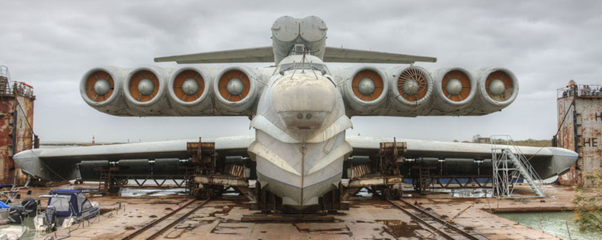
Watch: The 380-Ton ‘Caspian Sea Monster’ Plane Emerges From the Water for the First Time in 30 Years
The lun-class ekranoplan was pulled from the water by three tug boats and two escort vessels., rachel cormack.
Digital Editor
Rachel Cormack's Most Recent Stories
- This Blinged-Out Patek Philippe Nautilus Was Seized by U.K. Police. Now It’s up for Auction.
- A Michael Jordan Card Worth Over $1 Million Will Lead Fanatics and Sotheby’s First Auction
- Chanel Just Unveiled a Watch Necklace That Lets You Listen to Music and Take Calls
- Share This Article

Is it a boat? Is it a plane? Is it the Loch Ness monster? The Lun-class ekranoplan, colloquially known as “The Caspian Sea Monster,” is arguably a mish-mash of all three, and has just reared its head for the first time in 30 years.
Related Stories
- Rescuers Find 5 Bodies Aboard the Sunken ‘Bayesian’ Superyacht
- BMW Is Making an ‘Entry-Level’ Race Car Based on the M2
- Why McLaren Wants Its Supercars to Sell for Higher Prices
The Lun was slowly shepherded along the shores of the Caspian Sea and pulled from the water in June by three tug boats and two escort vessels. No easy feat considering the superplane weighs 380 tons and has a 148-foot wingspan. The mammoth effort took a total of 14 hours and required the careful coordination of several vessels, along with the assistance of rubber pontoons, as reported by CNN.

Denis Abramov
The supersized relic, which is currently sitting on a stretch of coast in the South of Russia, will be the centerpiece of a new military museum called Patriot Park. It’s slated to open in the city of Derbent in late 2020. Until that time, the Lun will remain alone on the beach.
While the dilapidated plane currently looks like nothing more than a ginormous hunk of aerodynamic scrap metal, it was once a formidable machine. Fitted with eight gutsy turbofans, it could hit speeds of up to 340 mph and launch six anti-ship missiles from flight.
Furthermore, by taking advantage of an aerodynamic principle known as “ground effect,” it could seamlessly glide over water without actually touching it. This is a nifty characteristic of all ekranoplans, a.k.a. ground effect vehicles, which skim the surface of the water at a height of between 3 feet to 16 feet. This makes them difficult to detect by radar and perfect for seaborne attacks. The mammoth aircraft could even take off and land in tumultuous weather while facing waves of up to 8 feet.
The ekranoplans covered the vast inland body of water between the Soviet Union and Iran, which scored them the nickname “Caspian Sea Monster.” This particular monster was the last of its breed and was mothballed by the Russian military when the Soviet Union collapsed in the 1990s.

If you can’t make it all the way to Russia to check out this Lun, keep your eyes on the sky. Ekranoplan technology is being examined once again by developers in China, Singapore, Russia and the US. In fact, Singapore’s Widgetworks has already created a Lun prototype. Bring on the monsters.
Rachel Cormack is a digital editor at Robb Report. She cut her teeth writing for HuffPost, Concrete Playground, and several other online publications in Australia, before moving to New York at the…
Read More On:
More aviation.

President Biden Finally Took the First Flight in the Long-Delayed ‘Marine One’ Helicopter

Luxury Airline Beond Is Now Flying Between Milan and the Maldives

Electric Air Taxis Are Poised to Help L.A. Transport Fans During the 2028 Olympics

The First Private Spacewalk Could Happen This Month

Meet the Wine Club That Thinks Differently.
Receive editor-curated reds from boutique California producers four times a year.
Give the Gift of Luxury
Latest Galleries in Aviation

From Swanky Lounges to Spacious Showers: 6 Private Jet Interiors That Are Like Penthouses in the Sky

8 Exciting Super Light Aircraft Landing at the World’s Largest Airshow
More from our brands, chanel buys stake in high-end watchmaker mb&f, nfl’s virtual chain gangs not yet ready for primetime, profits crumble by 80% at iqiyi, chinese video streamer, in second quarter, skulptur projekte münster names croatian curatorial collective what, how & for whom as new artistic directors, the best yoga mats for any practice, according to instructors.
- Experiments
- Green Buildings
- Green Designs
- Green Electronics
- How to…
- Climate Change
- Green Policy
- Energy news
- Energy Storage
- Geothermal Power
- Hydro Power
- Hydrogen Power
- Air powered
- Car industry
- Efficient engines
- Electric Vehicles
How to Plan an Eco-Friendly Vacation

How Remote Offices Can Help Companies Go Green

Energy Saving Tips to Save on Electricity Bills and Make Your Home Eco-Friendly

World’s First Plant-Based Running Shoes- by Reebok

UK Student Designs Bioplastic out of Fish Scales and Skin

Eco-Friendly Meat is Here… And No Animals Were Harmed in its Making

The Environmental Impact of Food Waste

How Restaurants Can Become More Sustainable

How to Find an Eco-Friendly Apartment in Boston (or any other town)

3 Ways Drivers can Live Greener

How to Reduce Commercial Electricity Demand Charges
8 ways to maximize your smartphone battery’s lifespan.

Innovative Device Harnesses Heat at Night

New Hyundai Sonata Hybrid Goes 1,300km a Year on Its Solar Panel Alone

Sydney Is in a State of Emergency to Fight Climate Change

Tesla Opens Up Model 3 Sales to Romania, Poland, Hungary and Slovenia

New Tesla Roadster to Feature Cold Air Thrusters, Could Even Fly

Electric Mini Hardtop Officially Revealed in July

The global transition to clean energy – explained in 12 charts
- Green Energy
Jaron Dickson's Hydrogen-Powered EkranoYacht Will Perform 250 MPH Travels

An air cushion between the wings and the water is created when Dickson’s flying boat hovers above the sea. He called his baby “EkranoYacht.”
Despite its similarities with the Russian invention, the EkranoYacht is fueled with the cleanest energy carrier in the universe: hydrogen. The onboard fuel cells will only emit water as output, and will propel the thing to a top speed on 250 miles per hour, being able to carry six. Because the drag is greatly reduced when the boat floats above the water, the fuel consumption will be even smaller than that of a normal boat (that would have never been able to reach this speed, anyway).
At first, the EkranoYacht will be a luxury, of course. After a while, if very successful, it might just be the next way of sea transportation. That will be the moment when humanity will have gotten over the classic boats used for thousands of years.
By the way, the Russian Ekranoplan used to travel 66 feet above the water, weighed 550 tons and had a speed of up to 460 mph, so you can imagine how much fuel it actually spent. At that speed, though, a vehicle acts more like a plane than as a boat, but without flying very high.
[via gas2 ]
RELATED ARTICLES MORE FROM AUTHOR

Hydrogen Fuel Cell Flying Car Reaches 400 Miles of Range

Hydrogen’s Recent Ascension as Fuel for Future Electric Cars

Hyundai/Toyota Partnership to Sell 1,000 Hydrogen-Powered Trucks

Korea Focuses Towards Increasing Hydrogen Vehicles Presence

Researchers Surpassed Theoretical Efficiency Limit on Biohydrogen Production
New hybrid catalyst generates hydrogen from water more efficiently.

Toyota Expands Line of Hydrogen-Powered Cars

How Hydrogen Can Become the Fuel of Choice in the Future

Toyota Tri-Gen: Water, Electricity and Hydrogen from Bio-Waste
This is a cool and nice learn. The blog is published in a way that it’s so easily readable and understand. I’m a fan of your website. Thanks for sharing this info.
LEAVE A REPLY Cancel reply
Save my name, email, and website in this browser for the next time I comment.
This site uses Akismet to reduce spam. Learn how your comment data is processed .
EVEN MORE NEWS

Eco-Friendly Meat is Here… And No Animals Were Harmed in its...

POPULAR CATEGORY
- Electric Vehicles 1498
- Solar Power 1356
- Climate Change 751
- Energy Storage 685
- Pollution 626
- Car industry 579
- Green Policy 568
Privacy Overview

Japanese Ground-Flying Plane Project Hopes to Compete With MagLev Trains
International luxury lifestyle magazine for affluent audience.Since 2009
- Cigars & Spirits
- Real Estate
- Watches|Jewelry
- Sport & Health
- Best Of Luxury
EkranoYacht Flying Yacht Concept
The EkranoYacht (designed by Mr Jaron Dickson from Monash University) is a hydrogen powered wing-in-ground effect vehicle for permanent residence – set for 2025. The project has the liveability of a yacht and the convenience of an aeroplane.
EkranoYacht flying yacht concept is inspired by the ekranoplans developed in URSS era. This type of vehicle called in Russian ekranoplan uses so called ground effect – extra lift of large wings when in proximity to the surface. For this reason they have been designed to travel at a maximum of three meters above the sea but at the same time could provide take off, stable “flight” and safe “landing” in conditions of up to 5-meter waves. These crafts were originally developed by the Soviet Union as high-speed military transports, and were based mostly on the shores of the Caspian Sea and Black Sea. In 2005 crafts of this type have been classified by the International Marine Organization so they probably should be considered flying ships rather than swimming planes.
The conventional ways of living have changed dramatically, people are less bound by the country or topographical location which they reside. Using hydrogen power and flying 4m above the waters surface , the EkranoYacht project focuses on more efficient sea travel and protecting the environment. To truly show your wealth and success is freedom, and the ultimate freedom is bringing you home where ever you go.
EkranoYacht performs at approximately 400kph in full flight. It can tackle waves of up to 3.5 m and can also be used as normal yacht when necessary. The 36.5m craft can house 6 people comfortably. The interior design was a very important part of the project, because if people are going to give up their static home living arrangements, there can’t be any sacrifice moving on to the EkranoYacht.
More: student.designawards
Privacy Overview
The Khanty-Mansi Autonomous Region (Yugra) is located in the centre of the West Siberian Plain. It borders on the Yamal-Nenets Autonomous Region in the north, the Komi Republic in the northeast, Sverdlov Region in the southwest, Tobolsky Region in the south, and Tomsk Region and Krasnoyarsk Territory in the southeast and east. The region spans 1,400 km east to west from the eastern slopes of Northern Ural almost to the banks of the Yenisey; and north to south - 900 km from the Sibirskiye Uvaly to the Konda taiga. The length of the borders is 4733 km. The relief is a combination of plains, foothills, and mountains. The highest elevations are Narodnaya Mountain in the Pre-Polar Urals (1894 m) and Pedy Mountain in the Northern Urals (1010 m). The Ob, with a length of 3,650 kilometers and Irtysh, whose length is 3,580 kilometers, their tributaries, and many smaller rivers form the area`s river system. Altogether, there are nearly 30 000 rivers in the area. There are nearly 290 000 lakes with an area of more than 1 hectare. Larger lakes (area greater than 100 km ) include Kondinsky Sor, Leushinsky Tyman, Vandemtor, and Tromemtor. The distance from Moscow is 2,500 km, from Irkutsk is 3,500 km. and from the largest city in the district - Surgut is 300 km. Khanty-Mansiysk (founded in 1582, population 101,000 as of 2019)
535,000 km , rank 9 in the country. 1,700,000 as of 2019, national composition: Russian 68%, Tatar 7,6%, Ukrainian 6%, Bashkir 2,5% the indigenous population (Khanty, Mansi, and Nenets) is 2,2%.The climate is temperate continental, characterized by a rapid change in weather conditions especially in transitional periods - from autumn to winter and from spring to summer. Winters are long, snowy and cold. The average January temperature in the district ranges from -18 to -24C. Extreme cold conditions may last for several weeks with the average air temperature below minus 30C. Summer is short and warm. The warmest month of July is characterized by average temperatures from + 15C (in the northwest) to + 18.4C (in the southeast). The absolute maximum reaches 36C. Climate formation is significantly influenced by the protection of the territory from the west by the Ural Range and the openness of the territory from the north, which facilitates the penetration of cold Arctic masses, as well as the flat character of the area with a large number of rivers, lakes and swamps.
Ugra is the historical homeland of the Ob-Ugric peoples first of all: Khanty, Mansi, Nenets and Selkups. They were engaged in hunting, fishing, and cattle breeding. After the Turkic peoples pressed them from south to north, these peoples transferred their skills to more severe conditions. It was in a new place that the Ugrians began to domesticate the deer. In the XII-XIII centuries. in the Irtysh and Priobye formed territorial clan associations of the Khanty and Mansi, called the principalities. From the second half of the XIII century a new factor in the development of the territory was its entry into the Golden Horde. At the end of the XIV century the collapse of the Golden Horde led to the separation of the Tyumen Khanate. In 1495, the Siberian Khanate was formed, the capital of which was the city of Kashlyk. It was then that the basic principles of the political-administrative and socio-economic organization of the territory developed. At this time, it was called Ugra.
225,562 hectares in the Soviet and Berezovsky regions of the Khanty-Mansiysk Autonomous Region, in the valley of the Malaya Sosva River.Of the mammals, sable, wolverine, ermine, weasel, common squirrel, muskrat, otter, elk, deer, bear and a number of other species are common here. Less common are arctic fox and lynx. A specially protected species is the North Asian river beaver, listed in the Red Books of the International Union for Conservation of Nature and the Russian Federation.
93,000 hectares on the territory of two districts of the Khanty-Mansi Autonomous Region - Khanty-Mansiysk and Kondinsky.The basis of its activity is the conservation of the population of taiga reindeer, as well as the reproduction of valuable hunting and Red Book species of animals. The reserve is part of the reserve "Malaya Sosva". Among the permanent residents of the reserve reindeer, otter, ermine, column, squirrel, hare, muskrat can be found. Of the large predators, you can often find a wolf, less often - wolverine and lynx. Meetings with chipmunks, affection, mole, and water voles are frequent. In summer, roe deer enters the territory of the reserve, Arctic fox in winter. Under special protection of the reserve employees are mainly game animals - sable, bear, otter, fox. Of the birds, a white owl, a white-tailed eagle and an osprey are protected.
650,000 hectares in the rural settlement of Ugut, 300 kilometers from Surgut city.Almost 2/3 of the reserve is covered with forests, the rest are swamps. The swamps of the reserve are part of the largest swamp massif in the world - Vasyugana. There are also quite common transitional between swamps and forest communities. The most common of these is ryam - a swampy pine forest. The most prominent representatives of plant families are cereal, Asteraceae, and sedge. Quite often there are orchid and buttercups. In general, 332 species of vascular plants, 195 species of lichens, 114 species of moss and more than 500 species of mushrooms are preserved. The fauna of the reserve is also quite rich and diverse, birds are especially distinguished - out of 262 species of vertebrates, 216 species are represented by birds. Of these, only 30 species fly here by chance, the rest are regular inhabitants of this zone. However, you can not see all this bird diversity all year round - most of them fly away for the winter to warmer regions. Mammals are represented by 40 species, more than half of which are rodents and shrews. The least widespread family of the reserve is feline, represented by only one species - trot. In addition to lynxes, other predators such as wolverine, sable, ermine, and badger live in the reserve. Also habitual inhabitants are the wolf and the fox, the population of which varies depending on the amount of game. Among ungulates you can meet moose and reindeer. 6,500 hectares Knanty-Mansiysk citySamarovsky Chugas is the largest natural site in Khanty-Mansiysk and a true paradise for lovers of ecotourism. The park is perfect for rest and walks: the pristine nature and natural beauty of these places, carefully preserved by the ancient peoples of the Khanty and Mansi for many centuries, fascinates anyone who has ever visited these parts. 500,000 hectares in the center of the West Siberian Plain 200 kilometers from the city of Beloyarsky and 300 kilometers from the city of Surgut.The natural park is the custodian of the indigenous inhabitants of this region. There are many secrets of the culture and life of the small peoples of the North, which makes this place one of the most mysterious in the region. The heart of the nature park and one of its main objects is - a sacred place for the indigenous peoples of the North Ob. In the center of Lake Numto is the Holy Island, where Khanty and Mansi pay tribute to the lake - at the beginning of winter, they gather on the island to perform a deer sacrifice rite.
The capital of Yugra – Khanty-Mansiysk- is situated on , and those who live here believe that this fact brings fortune to the residents and visitors of the city. The territory gained notoriety as a place of exile for prisoners of State. Prince Dmitry Romodanovsky served his sentence in ; Count Andrei Osterman was exiled here in 1742; and the large family of the princes Dolgorukov, in 1798. Prince Menshikov and his daughter Mariya are buried in these lands where they were exiled. The city also has many opportunities for cultural tourism. One of the most famous museums that have been actively restored recently is , founded in 1930. The museum has accumulated rich collections on the history of the region, life and activities of indigenous peoples, nature, the Soviet period of history, the collection has unique exhibits: the remains of animals from the Paleozoic era, manuscripts of the oldest monastery in Siberia. The museum’s exposition includes the located at the foot of the Samarovsky remnant, where ancient rocks of the earth are exposed, and on the top there is a possible residence of Prince Samara. In the Archeopark itself you can see a complex of bronze sculptures of a herd of mammoths, a rhinoceros, a cave bear and other prehistoric animals. In the heart of Khanty-Mansiysk is another open-air Initially, the museum complex was a collection of traditions, life and culture. Today, “Torum Maa” consists of several exhibits that recreate in great detail the residential and household buildings of the ancient Ugrians, with household items, jewelry and other exhibits. The museum has a cult site where Khanty and Mansi worship their deities, who have preserved the faith of their ancestors. Natural Archaeological Park is stretched for 8 kilometers along the right bank of the Ob, to the west of Surgut. The remains of ancient buildings, sanctuaries, burial grounds of the Stone Age have been preserved in the tract. The study of history always involves not just observation, but also some immersion in the era, life. This opportunity is available for tourists who visit the in Selirovo. It is located in the artistic and architectural ensemble of the late XIX - early XX centuries, and now the museum has a lot of ethnographic exhibits, as well as installations showing traditional life. The museum hosts master classes in ancient crafts. The greater Khanty Mansi Autonomous Region contains around 70% of Russia’s developed oil fields, about 450 in total, including Samotlor, which is the largest oil field in Russia and the sixth largest in the world. The Khanty-Mansiysk is a unique museum located in a modern building in the city center. The main task of the museum is to collect the most complete and reliable information on the history of the formation and development of the oil and gas complex in the region, industry workers and their labor achievements. The exposition was based on archival documents and photographs related to the history of oil and gas production in Ugra. A special pride is the excellent mineralogical collection of quartz mined in the deposits of the Subpolar Urals. The mass of the largest exhibit is 300 kg. is a unique cultural institution, which includes the creative workshop of the famous artist Gennady Raishev, as well as a museum of his works, the main theme of which is the magnificent nature of the native land, life of the indigenous inhabitants of Ugra and the original character of the Siberians. are also offered in the Khanty-Mansiysk District, the visiting card of which is pheasant hunting in the hunting grounds on the banks of the Gornaya River. Many of the Khanty, the Mansi, and the Nenets still maintain the traditional way of life in Ugra. The offer an opportunity to see the traditional way of life of the descendants of the ancient Ob Ugrians. Such tours are available in the indigenous villages of the Nizhnevartovsk, the Khanty-Mansiysk, the Surgut, the Berezovo, and the Beloyarski districts. : it takes 30 min. to get there by bus from Khanty-Mansiysk. There you can plunge into the atmosphere of folk festivals, to taste Russian traditional dishes such as pelmeni, gribnitsa, milk mushrooms, stroganina, home-made bred, to get acquainted with rural amusements and games. The guests may experience the ceremony of initiation into the Siberian and get a special certificate in support. is located on the outskirts of the national village of Agan, 400 km from Khanty-Mansiysk. In a small area, an off-season camp, a bathhouse, a shed and a plague were erected; there is also a glacier, coral, farm buildings, and on the shore there are stoppers for fishing. Here you can ride on reindeer teams or snowmobiles, on tubing from a hill. Fishing is organized all year round. Master classes in traditional crafts, cutting and cooking fish are held. You can also try national cuisine here. in Khanty-Mansiysk is one of the central attractions of not only the city, but the entire district. This is an amazing building in terms of architecture, built in 1999 using the most modern technologies. is a historical and ethnographic complex located in a picturesque place in the central part of the city. There are 14 wooden houses on the territory. All of them represent a reconstruction of old buildings that once stood in different parts of the city, but subsequently assembled into a single architectural ensemble. The gem of the Khanty-Mansiysk Autonomous Okrug – Ugra is the unique beauty of Northern and Polar Ural mountains with the highest peak of the Urals - (1,895 m). The highest peak of the Polar Urals is (1,499 m). The mountain is unusual for its plateau-shaped peak, from which sharp ridges extend to the side. On the slopes there are several glaciers and snowfields that do not have time to melt during the short and cold polar summer. Another tourist attraction of Ugra is . Mineral resources of the region include plenty of balneotherapeutic resources - mineral springs and muds. Several cities of the Okrug offer natural treatment opportunities: "Kedrovy Log" sanatorium in Surgut, city clinic balneary in Kogalym, "Samotlor Neftyanik" sanatorium in Nizhnevartovsk, "Tyumen-Trans Gas" sanatorium in Yugorsk, "Yugorskaya Dolina" in Khanty-Mansiysk and Khanty-Mansiysk city clinic balneary. In addition sapropel muds have been found in 160 lakes of the Autonomous Okrug, the medicinal properties of which are comparable to the muds of the famous Russian resorts.
The festival has been held annually since 2002 in Khanty-Mansiysk in late February - early March. Its permanent president is Sergey Soloviev. Films of debutant directors from different countries take part in the competition program. Within three to five days, several venues host sessions, concerts, performances, meetings with directors and actors, and round tables. Every year, a movie star comes to the festival. So, in different years, the honorary guests of the festival were Nastasya Kinski, Fanny Ardan, Catherine Deneuve, Christopher Lambert and others. It takes place every year in early December in Khanty-Mansiysk. Almost all producers of the region, including farmers, bring their products to the exhibition. Here you can buy fresh fish and meat delicacies, wild plants, clothes with national color, souvenirs right from the manufacturers. An international cultural forum takes place in Surgut in the fall, usually in October. The festival acquaints the audience with the work of authors and groups from cities located on the 60th northern parallel. In Surgut come artists and musicians from Russia, the USA, Estonia, Sweden, Finland, from the Faroe Islands (Denmark). The festival hosts numerous concerts, exhibitions, performances. In the traditional holiday arrange concert performances, children's entertainment programs, races on catamarans, in the program of the holiday competitions are held: "My favorite fishing", the best fish soup "Our good ear", "the Best smoked fish". Held in summer: June-July. The cycle of events includes swimming competitions on columns, book exhibitions, master classes, creative workshops, children's educational competitions, game programs, and games of indigenous peoples of the world.
An intrepid French adventurer set off to Russia’s far north - and explored the harsh winter in this Siberian city, where mammoths once lived.
|
|
|
|
|

| THU | (22.08, evening) | 21 / 19 | |
| FRI | (22.08, night) | 18 / 16 | |
| FRI | (22.08, morning) | 17 / 15 | |
| FRI | (22.08, day) | 17 / 15 |
Our Associated Organizations
| Inter-Baikal Cultural Organization | ||||
|
Siberian Tourist Organization | ||||
Our Usefull Links
World Wildlife Fund
Baikal Environmental Wave


Share ×

Scan the QR code and open PeakVisor on your phone
❤ Wishlist ×
See all region register, peakvisor app, khanty-mansiysk autonomous okrug – ugra.
Welcome to the land of sheer silent whiteness. Its vast expanses are filled with fresh Arctic air, howling winds, and the spirit of true adventure. Come with us to the lands of the ancient Khanty and Mansi tribes that survived in this harsh climate of the Nether-Polar Urals . See the mountains that defy any logical or geological reason for their existence. Experience the wonders of this sparsely populated land where you can hardly see a human trace. Welcome to Yugra!
Flora & Fauna
Water resources, landmarks and tourism, major mountains, mount narodnaya, mount zaschita, mount neroyka, the pyramid mountain, samarovskaya mountain, ski and sports facilities, protected sites, reserves, national and natural parks, rivers and lakes, major cities, khanty-mansiysk.
The Khanty-Mansiysk Autonomous Area – Yugra (KhMAO) is located in the central part of the West Siberian Plain, stretching from west to east from the Ural Range to the Ob-Yenisei Watershed. The vast areas of this plain, as well as the Lower Priob region, are considered one of the most recently inhabited areas.

The Khanty-Mansiysk Autonomous Area (KhMAO) was established in 1930. Its name comes from two main northern indigenous peoples – the Khanty and the Mansi. From 1944 it was legally part of the Tyumen Region , but in 1993 the Area received autonomy and became a full-fledged territorial entity of the Russian Federation. It is a part of the Urals Federal District. The administrative centre is the city of Khanty-Mansiysk , whereas the largest city is Surgut. The word Yugra was introduced to the name of the Khanty-Mansiysk Autonomous Area in 2003 to pay tribute to the old name used by the locals to call the territories lying beyond the North Urals.
The KhMAO borders the Komi Republic in the north-west, the Yamalo-Nenets Autonomous District in the north, the Krasnoyarsk Area and the Tomsk Region in the east and south-east, the Tyumen Region in the south and the Sverdlovsk Region in the south-west.
The area of the territory is 534,801 sq.km, the length from north to south is 800 km, from west to east is 1400 km. The population of this huge territory is 1,674,676 people as of 2020, which is the same amount as people living in Barcelona or Munich.

The main part of the territory is a huge, poorly dissected plain where absolute elevation marks rarely exceed 200 meters above sea level. The western part of the KhMAO territory is characterized by low and middle mountainous terrains with some Alpine relief featured in the Subpolar Urals. Here are ridges and spurs of the mountain system of the North Urals and the Subpolar Urals. The maximum absolute elevations are on the border with the Komi Republic . Mount Narodnaya (1,895m) is the highest peak.
More than 800 species of higher plants grow in the Khanty-Mansi Autonomous Area . Almost the entire territory is covered by taiga forests that occupy about 52% of the area. Spruce, fir, pine, cedar, larch, birch, alder grow here. In the northern parts of the area, the composition of the vegetation is greatly influenced by perennial permafrost. Light lichen grasslands which are used as deer pastures are widespread there. Tundra dominates in the mountainous and hilly areas. River floodplains and lowlands are characterized by meadow vegetation, the so-called water meadows. High floodplains of large rivers are mainly covered with woods that mainly feature willows, birches and aspens. Forests and swamps are rich in berries and various valuable plants, most of which are used in traditional indigenous medicine.

The animal world is typical for the Russian taiga zone. There are 369 species of vertebrates. Mammals are represented by 60 species (28 of them are commercial species). The most common and valuable of them are wild reindeer, elk, fox, sable, fox, squirrel, marten, ermine, Siberian weasel, polecat, mink, weasel, otter, hare and others. Wolverine and West Siberian river beaver are included in the Red Book of Russia.
There are 256 bird species in the region, including 206 sedentary and nesting species. Some rare bird species are listed in the Red Book. There are 42 species of fish in rivers and lakes. Of these, 19 species are commercial, among them are starlet sturgeon, lelema, muksun (whitefish), pelyad, chir, lake herring, wader, tugun, freshwater cod, pike, ide, roach, bream, fir, perch, ruff, golden and silver crucian carp, carp (carp is grown in the cooling ponds of the Surgutskaya and Nizhnevartovskaya hydroelectric plants). Sturgeon is listed in the Red Book. There is an abundance of mosquitoes and gnats in the area, the greatest activity of which is in the second half of summer.

Yugra can boast of over 2 thousand large and small rivers, the total length of which is 172,000 km. The main rivers are the Ob (3,650 km), the Irtysh (3,580 km). These are some of the largest rivers in Russia. Other significant rivers include the tributaries of the Ob (the Vakh, Agan, Tromyogan, Bolshoy Yugan, Lyamin, Pim, Bolshoy Salym, Nazym, Severnaya Sosva, Kazym rivers), the tributary of the Irtysh (the Konda River) and the Sogom River. Ten rivers are over 500 km long. All the Yugra rivers with the exception of the rivers in the Ural part of the region are characterized by rather slow currents, gentle slopes, some surge wave phenomena, spring and summer floods. The Ob River basin extends over a distance of 700-200 km from the mouths of its tributaries. Such abundance of water facilitates the appearance of floodplain swamps and seasonal lakes.
The region's swamps are predominantly of the upper and transitional type. Those water basins occupy about a third of the region. About 290,000 lakes with the area of more than 1 ha are surrounded by swamps and forests. The largest lakes are Tursuntsky Tuman, Levushinsky Tuman, Vandemtor and Trmemtor. The deepest lakes are Kintus (48 m) and Syrky Sor (42 m). However, most of the lakes (about 90%) are modest and quite small and have no surface runoff.
The area is rich in resources of fresh, mineral and thermal underground waters, which are still insignificantly used.

The climate is moderately continental. Winters are harsh, snowy and long, and summers are short and relatively warm. The territory is protected from the west by the Ural Mountains but its openness from the north has a significant impact on the climate formation because cold air masses from the Arctic freely penetrate the area. The flat character of the terrain with a large number of rivers, lakes and swamps also has its impact. Most of the precipitation falls during the warm seasons. But even with a small amount of precipitation, their evaporation is very low, which as a result contributes to the formation of the zone of excessive moisture throughout the Yugra. The snow cover is stable from late October to early May, its height varies from 50 to 80 cm. The region is characterized by a rapid change of weather conditions, especially in transitional seasons (autumn and spring), as well as during the day. Late spring and early autumn frosts are rather frequent and can happen even until mid-June. Average January temperatures range from -18ºC to -24ºC (0 F to -11 F) and can reach -60ºC to -62ºC (-76 F to -80 F) when the northern cold air masses break through. The average temperature in July, the warmest month of the year, ranges from +15ºC to +20ºC (+59 F to +68 F) and on very rare days can reach a maximum temperature of +36ºC (+97 F). The prevailing wind direction is north in summer and south in winter.
The weather in the mountains is quite changeable and cool even in summer. The best time to visit the region's mountains is between July and mid-August.
The Yugra of the Khanty-Mansi Autonomous Area has a huge natural resource potential. These are oil and gas deposits, forests, gold and iron ore deposits, as well as bauxites, copper, zinc, lead, niobium, tantalum, brown and hard coal deposits, rock crystal, quartz and piezo quartz, peat deposits, etc. The region has plenty of natural resources. In terms of natural gas reserves, the Yugra ranks second in the Russian Federation after the Yamalo-Nenets Autonomous District .
The industry is dominated by oil and gas production, power generation and processing industries, including woodworking except for pulp and paper production.

The Khanty-Mansi area has very developed tourism of all kinds. There is a modern infrastructure for cultural exploration as well as for active recreation.
Fans of sports and eco-friendly tourism will be able to conquer majestic mountains and raft down picturesque rivers, enjoy the beauty of nature in nature reserves and natural parks. The hills and mountains of this area open up endless opportunities for skiing and snowboarding.
The mountainous part of the Subpolar Urals located on the territory of the Khanty-Mansi Autonomous Area is very beautiful. The highest peaks of the Ural Mountains are situated here.
Being the highest point of the whole Urals, Mount Narodnaya (1,895 m), also known as Naroda and Poenurr and translated as People's Mountain is territorially situated in the Subpolar Urals, on the border of the Yugra Area and the Komi Republic . It is the highest point in European Russia outside the Caucasus. This leads to its large topographic prominence of 1,772 metres (5,814 ft).

The top of the mountain is half a kilometre from the border towards Yugra. As for the name of the mountain, scientists could not come to a common opinion for a long time, so there are two versions. According to one version, in the Soviet years, an expedition of pioneers gave the mountain a name in honour of the Soviet people - Narodnaya (the stress is on the second syllable). According to the other version, even before the arrival of the first Soviet tourists, the peak was named after the River Naroda (the stress is on the first syllable) flowing at the foot of the mountain. The Nenets peoples called the River Naroda Naro, which means a thicket or a dense forest, and the Mansi peoples called it Poengurr or Poen-urr, which translates as the top, or head. The maps used to refer to it as Mount Naroda or Mount Naroda-Iz. Nowadays, it appears everywhere as Narodnaya.
In the 1980s, someone set a bust of Lenin on the top of the mountain. Its remains can be found there to this day. There is one more symbolic relic there – some Orthodox believers erected a worship cross on top of Mount Narodnaya after a Procession of the Cross.
The slopes of the mountain are steeper in the north-east and south-west and there are many steep rocks on them. The south-eastern and northern parts of the mountain are more gentle but they are also covered with scree. Be vigilant and careful when climbing! On the slopes of the mountain, there are many not only boulders but also caverns filled with clear water as well as ice. There are glaciers and snowfields. From the north-eastern part of the mountain, you can observe Lake Blue near which tourists and travellers like to make bivouacs.

Mesmerizing with its beauty and inaccessibility, it attracts many tourists and fans of active recreation. This majestic mountain is quite remote from the settlements, so getting to it is not an easy task. The mountain is located in the Yugyd Va National Park , so it is necessary to register in advance and get a visit permit from the park administration. How to get to the park administration and get a permit, read the article on the Yugyd Va National Park .
Mountain Zaschita (1,808 m) is the second-highest peak in the Ural Mountains, after Mount Narodnaya . Mysteriously, the name of the mountain, which roughly translates as Defense or Protection Mount, does not correlate in any way with the Mansi names of the nearby mountains and rivers. The origin of the name is unknown. There are some speculations but we will consider just one of them. On the map of the Northern Urals which was made by the Hungarian researcher Reguli the closest peak to Mount Narodnaya was called gnetying olu. Its location coincides with that of the present-day Mount Zaschita . The name gnetying olu in the Mansi can be deciphered as a mountain on which there is some help from ice. The mountain is believed to protect deer grazing on glaciers from mosquitoes. So, early topographers called the mountain more briefly – Mount Defense. Indeed, the slopes of this mountain are covered with a lot of snow and glaciers (the Yugra, Naroda, Kosyu, Hobyu glaciers and others). And it is here that the Mansi shepherds bring their deer which can rest on glaciers and snow. Summarizing all the above, we can say that Zaschita Mount is to some extent protection for deer from mosquitoes. The very name Zaschita appeared on maps with the beginning of hiking tours in the Subpolar Urals.
Mount Neroyka (1,645 m) is 100 km from Neroyka village, the closest tourist base to this peak. In the 1950s, people who were engaged in quartz mining near the mountain worked and lived in this base. Later, a gravel road was built from the village of Saranpaul to the mountain for large-scale development of the quartz deposit. In recent years, the road has not been much used and is practically not cleaned from snow in winter. There has been a plant built 20 km down from the mountain for primary processing of quartz with the use of nanotechnologies. There is an annual big camping event near the mountain. It is organized by the Tourism Department of the Khanty-Mansi Autonomous Area. You can have a 1-hour helicopter ride to the mountain from the village of Saranpaul. Should you wish to fly from the city of Khanty-Mansiysk , be prepared to fly over the taiga for 2.5-3 hours.

Quite inquisitive tourists happened to discover, by a lucky chance, a Pyramid similar to that of Cheops but four times bigger. It is located on the territory of the Narodo-Ityinsky Ridge. The closest to the pyramid is the village of Saranpaul. The sizes of the found pyramid are as follows: the height is 774 m, in comparison to the Egyptian pyramid which is 147 m; the length of a lateral edge is 230 m whereas the Egyptian pyramid is 1 km. The pyramid is located precisely according to the cardinal directions, there is not a single degree deviation at that. The origin of the pyramid is unknown, scientists are still making assumptions. No traces of human activity were found near the pyramid. The only way to get here at this time is by helicopter.
Samarovskaya Mountain is another wonder that is baffling many people. It is dividing the city of Khanty-Mansiysk into northern and southern parts. Few now living residents know that in the old days the highest part of the modern city used to bear a plural name of the Samarovsky Mountains among which there were Mount Palenina, Komissarskaya, Miroslavskaya, Filinova, and Romanova. Originally, there was a village called Samarovo amidst these mountains. Until now, many issues bewilder both residents and scientists. How could a mountain form in the middle of the West Siberian Plain? What is inside it? Won't the weight of the buildings erected on the top of the mountain affect its height? The uniqueness of Samarovskaya Mountain is that it consists of numerous large stones, boulders, rocks that are absolutely foreign to this area. Scientists have not yet come to a consensus on the mountain’s origin.

The Yugra is very famous for its ski resorts, the main of which are:
- The Cedar Ravine ski resort (Surgut city, Naberezhny Ave. 39/1)
- Three Mountains (Trekhgorie) ski resort (30 km from Nizhnevartovsk, Ermakovsky settlement)
- Stone Cape (Kamenniy Mys) ski resort (near the city of Surgut)
- Pine Urman ski resort ( Khanty-Mansiysk , Sportivnaya Str., 24)
The far-away lands of the Yugra are the blessed sanctuaries for many animals as the area is rather hostile to a human There are reserves, natural parks, wildlife sanctuaries here that aim to protect the national treasures of the lands. Having visited these regions once, you would crave for coming back again and again to feel that unique sense of unity with nature, to forget about the urban fuss and and hustles whatsoever. The harsh but beautiful nature of this extraordinary area leaves an indelible trace in the soul of every person.

On the territory of the district there are 25 specially protected natural areas, the most famous of them are:
- The reserves are two: the Malaya Sosva Reserve and the Yugan Reserve, the latter was established in 1982 as the largest reserve of taiga landscapes. The purpose of the reserves was to study unobtrusively and carefully preserve the endemic flora and fauna without disturbing natural processes. Hunting and economic activities are prohibited here, which is important for the preservation of natural ecosystems.
- The natural parks are the Samarovsky Chugas Nature Park, the Siberian Sloping Hills (Uvaly), the Numto (also called Lake Numto), and the Kondinskie Lakes.
These reserves and natural parks offer tourists their own excursion programs to make visiting their territory much more enjoyable and educational.
The Samarovsky Chugas Nature Park is located in the center of Khanty-Mansiysk , on a small hill between the Ob and Irtysh rivers.
The territory of the Siberian Sloping Hills (Uvaly) natural park is 350 km away from the city of Khanty-Mansiysk . You can get there by helicopter or by plane. The office of the park is located at 7a Pionerskaya Street, Nizhnevartovsk.
The Kondinskie Lakes Natural Park is located 380 km from Khanty-Mansiysk . Half of the park is covered with swamps, but there is also a recreational area. There you can rest, swim, do some amateur fishing, picking berries (cowberries, cranberries) and mushrooms is permitted. There is only one independent walking route here, it runs for 3 km in the deep forest. It is a cool place for kids since the park is equipped with sports grounds, a pool and a small zoo where the kids can interact with brown bear cubs. What else, try the TaiPark, it is a rope course running at the height of 2.5 meters, having 15 stages, the full length is 125 meters. There is an opportunity to order water walking tours in the town of Sovetsky, which can be reached by train from Khanty-Mansiysk .

The Numto Nature Park is located almost in the center of the West Siberian Plain, in the Beloyarsk district of the Khanty-Mansi Autonomous Area, 300 km from the city of Surgut and 200 km from the town of Beloyarsk. It is located on the border of Yugra and Yamalo-Nenets Autonomous Area. The administration of the park is located at 2, Beloyarsky micro-district, 4a. The territory of the natural park is a treasure trove of archaeological and ethnocultural monuments. As of today, there have been discovered 20 architectural monuments, including fortified and not fortified settlements, places of worship abandoned by the peoples who lived here from the Stone Age to almost the present day. Researchers have also found 65 monuments of ethnic value, the main of which are worship objects, sacred places and cemeteries.
The Malaya Sosva Reserve includes several subordinated territories and sanctuaries, including Lake Ranghe-Tour. The reserve offers a 4-km walking guided route that gets the visitors introduced to the typical features and characteristics of flora and fauna of the region. The route is called Bear Trail and you can spot bears there (don’t come close though, we’ve already written how to behave if you meet a bear in the wild). Also, you will see the River Malaya Sosva, some marshes, ancient cultural monuments and other nice sights. Permission to visit the reserve can be obtained from the administration of the reserve at Lenina Str. 46, town Sovetskiy.
As to the Yugan Nature Reserve , it is inaccessible to common hikers who are afraid of flying since there are no roads to it. The only way to get there is taking a helicopter ride. You also must obtain a permit in the administration of the reserve, go accompanied by employees of the reserve, and only on special transport of the reserve (motorboat, snowmobile). The central manor of the Reserve and the administration are located in the village of Ugut. To get to this village, you should first go to the town of Surgut, then go to the town of Pyt-Yakh, and from it there is a road to the village of Ugut. It is about 100 km from Ugut to the southern border of the reserve i, and another 25 km to the nearest cordon. The administration works from Monday to Friday. You can request a permit via mail at [email protected] , order a guided tour at [email protected]

The Yugra lands are heaven for water sports aficionados. They can have some awesome fishing or go rafting along such rivers as: the river Naroda, the Deep Sabun, etc.
The Naroda River is 140 km long. It is the left tributary of the Manya River located in the Ob River basin. The river has its origin on the south-western slope of Mount Narodnaya . It is a mountain-taiga river with rapids, swifts, numerous rolls, which attracts interest among water tourists. However, it is usually not rafted very often.
The Deep Sabun River flows through the territory of the Siberian Sloping Hills Nature Park. The park has developed multi-day water routes. It is possible to raft along the river in summer and to go skiing along it in winter.
The Kondinskie Lakes are a system of lakes along the left bank of the Konda River. The largest lake is the Arantur, with pine forests on the northern side and sandy beaches well equipped for a nice relaxing me-time. The water heats up well in summer. The small river Okunevaya and the river Maly Akh flow into the lake. The Maly Akh comes in on the west side and connects lake Arantur with Lake Pon-Tour. This lake is the richest in fish, and there is also a parking lot for fishermen here. The streams connect Pon-Tour with small lakes Krugloe and Lopukhovoye. When you look at Lopukhovoe lake, you feel as if you have found yourself in a fabulous place: more than half of its surface is covered with white lilies, as well as yellow flowers of the water-beans. Then the river Big Akh, which flows into the river Konda, connects all the lakes into a single system. Along the river there are many archeological monuments such as forts and settlements which have paths to them. The southernmost lake of the park is Ranghe-Tour.

Yugra is not the easiest destination and not the most accessible, but the effort is well worth it. You should first get to the capital of Khanty-Mansiysk Autonomous Area – the city of Khanty-Mansiysk either by air or by train.
Khanty-Mansiysk is based on the premises of the former village Samarovo founded in 1582. It used to be the territory of the Khanty people and a pit stop for coachmen who rode their wagons across the country. The village was founded by Russian Count Samara, thus the name Samarovo. The modern city actually began to develop in 1930 because amidst the Siberian taiga there finally started to appear stone houses on the high bank of the Irtysh River. In 1940, the village was renamed into Khanty-Mansiysk by the name of the peoples living on this territory – the Khanty and the Mansi, and in 1950 it received the status of a town.

The city has several attractions. Mount Samarovskaya is probably the biggest natural and scientific wonder. It divides the city in two parts and causes many concerns for urban developers who always wonder whether this mountain can move making the buildings slide or even sink in.
Another beauty is the century-old cedar grove that is within the city limits. The grove is a part of the natural park Samarovsky Chugas. The word chugas in the language of the Khanty means a lonely hill in the low river floodplain.

The park is one of the main attractions of the city, it hosts an open-air ethnographic museum called the Torum Maa, a cultural and tourist complex called Archaeopark, a biathlon center. Kids and adults, nature lovers and fans of culture love this place dearly.
A memorial sign to Yugra's discoverers is installed on top of the Samarovsky Chugas. It is a tall stele pyramid divided into three portions. On the lower level, there is a restaurant, on the second level is a small museum, and on the third level there is an observation deck, 40 m above the ground, with a magnificent view of the Irtysh River and the river port. The pyramid is decorated by the bas-relief depicting the discoverers of the region, from the 16th-century Count Samara to the geologists of the 20th century.
Another trademark of Khanty-Mansiysk is the State Museum of Nature and Man. The museum hosts a gallery and a workshop of a famous artist G. Rayshev.
The city has a lot of small monuments generously spread around the city. There is the Khanty family resting on a camp, this monument is near the airport building. You can take a pic at the Golden Tambourine located at the intersection of Gagarin Street and Mira Street. Connoisseurs of culture should also visit the Sun – the Theatre of Ob-Ugrian Peoples, it is the world's first professional theatre of Khanty and Mansi peoples. And if you are travelling with kids, the Khanty-Mansiysk Puppet Theatre is a must-visit. In the period from May to October, you can take a boat ride to the confluence of two rivers – the Ob and the Irtysh. Yugra Service Co. operates such cruises, you can find more information locally at their address Tobolsk Trakt street 4, Khanty-Mansiysk .

Explore Khanty-Mansiysk Autonomous Okrug – Ugra with the PeakVisor 3D Map and identify its summits .
PeakVisor Hiking Maps
Be a superhero of outdoor navigation with state-of-the-art 3D maps and mountain identification in the palm of your hand!

Khanty-Mansi Autonomous Okrug
| Ханты-Мансийский автономный округ — Югра | |
| Other transcription(s) | |
| • Khanty | Хӑнты-Мансийской Aвтономной Округ |
| • Mansi | Ханты-Мансийский Aвтономный Oкруг |
| Anthem: | |
| Coordinates: 70°10′E / 62.250°N 70.167°E / 62.250; 70.167 | |
| Country | |
| Administrative center | |
| Government | |
| • Body | |
| • | (acting) |
| Area | |
| • Total | 534,801 km (206,488 sq mi) |
| • Rank | |
| Population ( ) | |
| • Total | 1,711,480 |
| • Rank | |
| • Density | 3.2/km (8.3/sq mi) |
| • | 92.0% |
| • | 8.0% |
| ( ) | |
| RU-KHM | |
| 86, 186 | |
| ID | 71800000 |
| Official languages | |
| Recognised languages | • ] |
| Website | |
Khanty-Mansi Autonomous Okrug — Yugra [lower-alpha 1] , commonly shortened to Khantia-Mansia, is a federal subject of Russia (an autonomous okrug of Tyumen Oblast ). It has a population of 1,532,243 as of the 2010 Census . [4] Its administrative center is located at Khanty-Mansiysk .
Administrative divisions
Demographics, settlements, ethnic groups, vital statistics, external links.
The peoples native to the region are the Khanty and the Mansi , known collectively as Ob-Ugric peoples , but today the two groups only constitute 2.5% of the region's population. The local languages, Khanty and Mansi , are part of the Ugric branch of the Finno-Ugric language family, and enjoy a special status in the autonomous okrug. Russian remains the only official language.
In 2012, the majority (51%) [7] of the oil produced in Russia came from Khanty-Mansi Autonomous Okrug, giving the region great economic importance in Russia and the world. It borders Yamalo-Nenets Autonomous Okrug to the north, Komi Republic to the northwest, Sverdlovsk Oblast to the west, Tyumen Oblast to the south, Tomsk Oblast to the south and southeast and Krasnoyarsk Krai in the east.
The okrug was established on December 10, 1930, as Ostyak-Vogul National Okrug ( Остя́ко-Вогу́льский национа́льный о́круг ). In October 1940, it was renamed the Khanty-Mansi National Okrug . In 1977, along with other national okrugs of the Russian SFSR , it became an autonomous okrug (Khanty-Mansi Autonomous Okrug). In 2003, the word " Yugra " was appended to the official name. [8]

The okrug occupies the central part of the West Siberian Plain .
Principal rivers include the Ob and its tributaries Irtysh and Vatinsky Yogan . There are numerous lakes in the okrug, the largest ones are Numto , Tormemtor , Leushinsky Tuman and Tursuntsky Tuman , among others. [9]
The northeasterly line of equal latitude and longitude traverses the Khanty-Mansi Autonomous Okrug.
Population : 1,674,676 (2020); [10] 1,532,243 ( 2010 Russian census ) ; [4] 1,432,817 ( 2002 Census ) ; [11] 1,268,439 ( 1989 Soviet census ) . [12]
Khanty-Mansi Autonomous Okrug has an area of 523,100 km 2 , but the area is sparsely populated. The administrative center is Khanty-Mansiysk , but the largest cities are Surgut , Nizhnevartovsk , and Nefteyugansk .
| | |||||||||
|---|---|---|---|---|---|---|---|---|---|
| Rank | Pop. | ||||||||
| | 1 | 380,632 | |||||||
| 2 | 277,668 | ||||||||
| 3 | 127,255 | ||||||||
| 4 | 101,466 | ||||||||
| 5 | 67,727 | ||||||||
| 6 | 58,565 | ||||||||
| 7 | 46,643 | ||||||||
| 8 | 44,646 | ||||||||
| 9 | 43,666 | ||||||||
| 10 | 39,570 | ||||||||
| Year | ||
|---|---|---|
| 1939 | 92,932 | — |
| 1959 | 123,926 | +33.4% |
| 1970 | 271,157 | +118.8% |
| 1979 | 569,139 | +109.9% |
| 1989 | 1,268,439 | +122.9% |
| 2002 | 1,432,817 | +13.0% |
| 2010 | 1,532,243 | +6.9% |
| 2021 | 1,711,480 | +11.7% |
| Source: Census data | ||
The Indigenous population ( Khanty , Mansi , Komi , and Nenets ) is only 2.8% of the total population in the Khanty-Mansi Autonomous Okrug. The exploitation of natural gas in Khanty-Mansi Autonomous Okrug has attracted immigrants from all over the former Soviet Union. The 2021 Census counted 17 ethnic groups of more than five thousand persons each. The ethnic composition is as follows:
Population of Khanty-Mansi Autonomous Okrug: [13]
| Ethnic Group | Population | % |
|---|---|---|
| 888,660 | 70.3% | |
| 79,727 | 6.3% | |
| 41,596 | 3.3% | |
| 29,717 | 2.4% | |
| 21,791 | 1.7% | |
| 21,259 | 1.7% | |
| 19,568 | 1.5% | |
| 15,268 | 1.2% | |
| 13,669 | 1.1% | |
| 12,361 | 1.0% | |
| 11,065 | 0.9% | |
| 9,990 | 0.8% | |
| 7,786 | 0.6% | |
| 7,085 | 0.6% | |
| 6,156 | 0.5% | |
| 5,562 | 0.4% | |
| 5,297 | 0.4% | |
| Other | 48,194 | 3.8% |
Historical population figures are shown below:
| Ethnic group | 1939 Census | 1959 Census | 1970 Census | 1979 Census | 1989 Census | 2002 Census | 2010 Census | 2021 Census | ||||||||
|---|---|---|---|---|---|---|---|---|---|---|---|---|---|---|---|---|
| Number | % | Number | % | Number | % | Number | % | Number | % | Number | % | Number | % | Number | % | |
| 12,238 | 13.1% | 11,435 | 9.2% | 12,222 | 4.5% | 11,219 | 2.0% | 11,892 | 0.9% | 17,128 | 1.2% | 19,068 | 1.3% | 19,568 | 1.6% | |
| 5,768 | 6.2% | 5,644 | 4.6% | 6,684 | 2.5% | 6,156 | 1.1% | 6,562 | 0.5% | 9,894 | 0.7% | 10,977 | 0.8% | 11,065 | 0.9% | |
| 852 | 0.9% | 815 | 0.7% | 940 | 0.3% | 1,003 | 0.2% | 1,144 | 0.1% | 1,290 | 0.1% | 1,438 | 0.1% | 1,381 | 0.1% | |
| 2,436 | 2.6% | 2,803 | 2.3% | 3,150 | 1.2% | 3,105 | 0.5% | 3,000 | 0.2% | 3,081 | 0.2% | 2,364 | 0.2% | 2,618 | 0.2% | |
| 67,616 | 72.5% | 89,813 | 72.5% | 208,500 | 76.9% | 423,792 | 74.3% | 850,297 | 66.3% | 946,590 | 66.1% | 973,978 | 68.1% | 888,660 | 70.3% | |
| 1,111 | 1.2% | 4,363 | 3.5% | 9,986 | 3.7% | 45,484 | 8.0% | 148,317 | 11.6% | 123,238 | 8.6% | 91,323 | 6.4% | 41,596 | 3.3% | |
| 2,227 | 2.4% | 2,938 | 2.4% | 14,046 | 5.2% | 36,898 | 6.5% | 97,689 | 7.6% | 107,637 | 7.5% | 108,899 | 7.6% | 79,727 | 6.3% | |
| Others | 1,026 | 1.1% | 6,115 | 4.9% | 15,629 | 5.8% | 43,106 | 7.6% | 163,495 | 12.7% | 223,959 | 15.6% | 173,536 | 15.5% | 219,465 | 17.3% |
| 102,138 people were registered from administrative databases, and could not declare an ethnicity. It is estimated that the proportion of ethnicities in this group is the same as that of the declared group. | ||||||||||||||||

Source: [15]
| Average population (× 1000) | Live births | Deaths | Natural change | Crude birth rate (per 1000) | Crude death rate (per 1000) | Natural change (per 1000) | Fertility rates | |
|---|---|---|---|---|---|---|---|---|
| 1970 | 281 | 5 959 | 2 025 | 3 934 | 21.2 | 7.2 | 14.0 | |
| 1975 | 415 | 9 450 | 2 572 | 6 878 | 22.8 | 6.2 | 16.6 | |
| 1980 | 649 | 13 901 | 4 116 | 9 785 | 21.4 | 6.3 | 15.1 | |
| 1985 | 1 041 | 25 130 | 4 863 | 20 267 | 24.1 | 4.7 | 19.5 | |
| 1990 | 1 274 | 21 812 | 5 354 | 16 458 | 17.1 | 4.2 | 12.9 | |
| 1991 | 1 276 | 19 060 | 5 884 | 13 176 | 14.9 | 4.6 | 10.3 | |
| 1992 | 1 270 | 15 849 | 7 132 | 8 717 | 12.5 | 5.6 | 6.9 | |
| 1993 | 1 274 | 14 531 | 9 401 | 5 130 | 11.4 | 7.4 | 4.0 | 1,59 |
| 1994 | 1 286 | 15 120 | 9 937 | 5 183 | 11.8 | 7.7 | 4.0 | 1,59 |
| 1995 | 1 298 | 14 418 | 10 041 | 4 377 | 11.1 | 7.7 | 3.4 | 1,46 |
| 1996 | 1 310 | 14 469 | 9 508 | 4 961 | 11.0 | 7.3 | 3.8 | 1,39 |
| 1997 | 1 330 | 14 640 | 8 497 | 6 143 | 11.0 | 6.4 | 4.6 | 1,34 |
| 1998 | 1 351 | 15 600 | 8 164 | 7 436 | 11.5 | 6.0 | 5.5 | 1,39 |
| 1999 | 1 359 | 14 728 | 8 476 | 6 252 | 10.8 | 6.2 | 4.6 | 1,29 |
| 2000 | 1 372 | 15 579 | 9 426 | 6 153 | 11.4 | 6.9 | 4.5 | 1,34 |
| 2001 | 1 398 | 17 130 | 9 863 | 7 267 | 12.3 | 7.1 | 5.2 | 1,43 |
| 2002 | 1 426 | 19 051 | 9 829 | 9 222 | 13.4 | 6.9 | 6.5 | 1,54 |
| 2003 | 1 445 | 19 883 | 10 000 | 9 883 | 13.8 | 6.9 | 6.8 | 1,58 |
| 2004 | 1 456 | 20 377 | 9 828 | 10 549 | 14.0 | 6.8 | 7.2 | 1,59 |
| 2005 | 1 466 | 19 958 | 10 415 | 9 543 | 13.6 | 7.1 | 6.5 | 1,54 |
| 2006 | 1 476 | 20 366 | 10 077 | 10 289 | 13.8 | 6.8 | 7.0 | 1,56 |
| 2007 | 1 487 | 21 887 | 10 093 | 11 794 | 14.7 | 6.8 | 7.9 | 1,66 |
| 2008 | 1 500 | 23 197 | 10 215 | 12 982 | 15.5 | 6.8 | 8.7 | 1,74 |
| 2009 | 1 513 | 23 840 | 10 107 | 13 733 | 15.8 | 6.7 | 9.1 | 1,77 |
| 2010 | 1 527 | 25 089 | 10 447 | 14 642 | 16.4 | 6.8 | 9.6 | 1,84 |
| 2011 | 1 543 | 25 335 | 10 072 | 14 642 | 16.4 | 6.5 | 9.9 | 1,86 |
| 2012 | 1 558 | 27 686 | 9 949 | 17 737 | 17.6 | 6.3 | 11.3 | 2,02 |

| Religion in Khanty-Mansi Autonomous Okrug as of 2012 (Sreda Arena Atlas) | ||||
|---|---|---|---|---|
| 38.1% | ||||
| Other | 5.5% | |||
| 11% | ||||
| and other native faiths | 0.9% | |||
| 23.1% | ||||
| and | 11% | |||
| Other and undeclared | 10.4% | |||
According to a 2012 survey [16] 38.1% of the population of Yugra adheres to the Russian Orthodox Church , 5% are unaffiliated generic Christians , 1% of the population adheres to the Slavic native faith (Rodnovery) or to Khanty-Mansi native faith. Muslims (mostly Tatars ) constitute 11% of the population. In addition, 23% of the population declares to be spiritual but not religious , 11% is atheist , and 10.9% follows other religions or did not give an answer to the question. [16] According to recent reports Jehovah's Witnesses have been subjected to torture and detention in Surgut. [18]
In Khanty-Mansi Autonomous Okrug, the primary transport of goods is by water and railway transport; 29% is transported by road, and 2% by aviation. The total length of railway tracks is 1,106 km. The length of roads is more than 18,000 km.
- Hockey Club Ugra
- List of Chairmen of the Duma of the Khanty-Mansi Autonomous Okrug
Related Research Articles

Khanty-Mansiysk is a city in west-central Russia. Technically, it is situated on the eastern bank of the Irtysh River, 15 kilometers (9.3 mi) from its confluence with the Ob, in the oil-rich region of Western Siberia. Though it is an independent city, Khanty-Mansiysk also functions as the administrative centre of Khanty-Mansiysky District, and the administrative center of Khanty-Mansi Autonomous Okrug–Yugra.
Nyagan is a town in the northwest of Khanty–Mansi Autonomous Okrug, Russia, located near the Ob River and 230 kilometers (140 mi) northwest of Khanty-Mansiysk. It is named after the Nyagan-Yugan River, a tributary of the Ob River. Population: 63,034 (2021 Census) ; 54,890 (2010 Russian census) ; 52,610 (2002 Census) ; 54,061 (1989 Soviet census) .

Megion is a town in Khanty-Mansi Autonomous Okrug–Yugra, Russia, located at the altitude of 45 meters (148 ft) above sea level, on the right bank of the Ob River, 380 kilometers (240 mi) east of Khanty-Mansiysk and 760 kilometers (470 mi) northeast of Tyumen. The area of the town is 50.51 square kilometers (19.50 sq mi) and the nearest airport is in Nizhnevartovsk. Population: 49,449 (2010 Russian census) ; 46,566 ; 39,783 (1989 Soviet census) .

Yugorsk is a town in Khanty–Mansi Autonomous Okrug, Russia, located in the northwestern part of the East-West lowland, 420 kilometers (260 mi) from Khanty-Mansiysk. Population: 34,067 (2010 Russian census) ; 30,285 (2002 Census) ; 24,928 (1989 Soviet census) .

Sovetsky is a town and the administrative center of Sovetsky District in Khanty-Mansi Autonomous Okrug, Russia, located 470 kilometers (290 mi) west of Khanty-Mansiysk, the administrative center of the autonomous okrug. Population: 26,495 (2010 Russian census) ; 23,230 (2002 Census) ; 21,123 (1989 Soviet census) .
Lyantor is a town in Surgutsky District of Khanty–Mansi Autonomous Okrug, Russia, located on the Pim River, 625 kilometers (388 mi) northeast of Khanty-Mansiysk, the administrative center of the autonomous okrug. Population: 38,992 (2010 Russian census) ; 33,011 (2002 Census) ; 22,071 (1989 Soviet census) .

Pokachi is a town in Khanty–Mansi Autonomous Okrug, Russia, located on the right bank of the Vatyegan River, 350 kilometers (220 mi) east of Khanty-Mansiysk and 800 kilometers (500 mi) northeast of Tyumen. Population: 17,171 (2010 Russian census) ; 17,017 (2002 Census) ; 11,536 (1989 Soviet census) .
Kogalym is a town in Khanty-Mansi Autonomous Okrug, Russia, located on the Inguyagun River 325 kilometres (202 mi) northeast of Khanty-Mansiysk. Population: 58,181 (2010 Russian census) ; 55,367 (2002 Census) ; 44,297 (1989 Soviet census) .

Beloyarsky is a town and the administrative center of Beloyarsky District in Khanty-Mansi Autonomous Okrug, Russia, located on the Kazim River, northwest of Khanty-Mansiysk, the administrative center of the autonomous okrug. Population: 20,283 (2010 Russian census) ; 18,721 (2002 Census) ; 20,534 (1989 Soviet census) .

Raduzhny is a town in Khanty-Mansi Autonomous Okrug, Russia, located on the Agan River, 475 kilometers (295 mi) northeast of Khanty-Mansiysk and 975 kilometers (606 mi) northeast of Tyumen. Population: 43,399 (2010 Russian census) ; 47,060 ; 43,726.

Pyt-Yakh is a town in Khanty–Mansi Autonomous Okrug, Russia, located on the east bank of the Bolshoy Balyk River, southeast of Khanty-Mansiysk. Population: 41,488 (2010 Russian census) ; 41,813 (2002 Census) ; 17,101 (1989 Soviet census) .

Beloyarsky District is an administrative and municipal district (raion), one of the nine in Khanty-Mansi Autonomous Okrug of Tyumen Oblast, Russia. It is located in the north of the autonomous okrug. The area of the district is 41,574 square kilometers (16,052 sq mi). Its administrative center is the town of Beloyarsky. Population: 9,766 ; 9,493 (2002 Census) ; 8,927 (1989 Soviet census) .

Khanty-Mansiysky District is an administrative and municipal district (raion), one of the nine in Khanty-Mansi Autonomous Okrug, Russia. It is located in the center of the autonomous okrug. The area of the district is 46,400 square kilometers (17,900 sq mi). Its administrative center is the town of Khanty-Mansiysk. As of the 2010 Census, the total population of the district was 19,362.

Kondinsky District is an administrative and municipal district (raion), one of the nine in Khanty-Mansi Autonomous Okrug of Tyumen Oblast, Russia. It is located in the south of the autonomous okrug. The district is 55,170 square kilometers (21,300 sq mi). Its administrative center is the urban locality of Mezhdurechensky. Population: 34,494 ; 35,018 (2002 Census) ; 36,640 (1989 Soviet census) . The population of Mezhdurechensky accounts for 32.1% of the district's total population.

Nizhnevartovsky District is an administrative and municipal district (raion), one of the nine in Khanty-Mansi Autonomous Okrug, Russia. The area of the district is 118,500 square kilometers (45,800 sq mi). Its administrative center is the city of Nizhnevartovsk. Population: 35,745 ; 33,508 (2002 Census) ; 28,288 (1989 Soviet census) .

Oktyabrsky District is an administrative and municipal district (raion), one of the nine in Khanty-Mansi Autonomous Okrug of Tyumen Oblast, Russia. It is located in the western central part of the autonomous okrug. The area of the district is 24,500 square kilometers (9,500 sq mi). Its administrative center is the urban locality of Oktyabrskoye. As of the 2010 Census, the total population of the district was 32,224, with the population of Oktyabrskoye accounting for 11.3% of that number.

Sovetsky District is an administrative and municipal district (raion), one of the nine in Khanty-Mansi Autonomous Okrug of Tyumen Oblast, Russia. It is located in the southwest of the autonomous okrug. The area of the district is 29,768.74 square kilometers (11,493.77 sq mi). Its administrative center is the town of Sovetsky. Population: 48,059 ; 44,720 (2002 Census) ; 73,247 (1989 Soviet census) . The population of the administrative center accounts for 55.1% of the district's total population.

Surgutsky District is an administrative and municipal district (raion), one of the nine in Khanty-Mansi Autonomous Okrug, Russia. It is located in the center of the autonomous okrug. The area of the district is 105,190 square kilometers (40,610 sq mi). Its administrative center is the city of Surgut. Population: 113,515 ; 106,624 (2002 Census) ; 74,685 (1989 Soviet census) .

Uray a town in Khanty–Mansi Autonomous Okrug, located on the Konda River 350 kilometres (220 mi) from Khanty-Mansiysk. Population: 39,457 (2010 Russian census) ; 38,872 (2002 Census) ; 37,198 (1989 Soviet census) .

Agirish is an urban-type settlement in Sovetsky District of Khanty-Mansi Autonomous Okrug, Russia. Population: 2,856 (2010 Russian census) ; 2,831 (2002 Census) ; 3,592 (1989 Soviet census) .
- ↑ Russian and Mansi : Ханты-Мансийский автономный округ — Югра, Khanty-Mansiyskiy avtonomnyy okrug — Yugra; Khanty : Хӑнты-Мансийской Aвтономной Округ
- ↑ Президент Российской Федерации. Указ №849 от 13 мая 2000 г. «О полномочном представителе Президента Российской Федерации в федеральном округе». Вступил в силу 13 мая 2000 г. Опубликован: "Собрание законодательства РФ", No. 20, ст. 2112, 15 мая 2000 г. (President of the Russian Federation. Decree # 849 of May 13, 2000 On the Plenipotentiary Representative of the President of the Russian Federation in a Federal District . Effective as of May 13, 2000.).
- ↑ Госстандарт Российской Федерации. №ОК 024-95 27 декабря 1995 г. «Общероссийский классификатор экономических регионов. 2. Экономические районы», в ред. Изменения №5/2001 ОКЭР. ( Gosstandart of the Russian Federation. # OK 024-95 December 27, 1995 Russian Classification of Economic Regions. 2. Economic Regions , as amended by the Amendment # 5/2001 OKER. ).
- 1 2 3 Russian Federal State Statistics Service (2011). Всероссийская перепись населения 2010 года. Том 1 [ 2010 All-Russian Population Census, vol. 1 ] . Всероссийская перепись населения 2010 года [2010 All-Russia Population Census] (in Russian). Federal State Statistics Service .
- ↑ "Об исчислении времени" . Официальный интернет-портал правовой информации (in Russian). June 3, 2011 . Retrieved January 19, 2019 .
- ↑ Official throughout the Russian Federation according to Article 68.1 of the Constitution of Russia .
- ↑ В Ханты-Мансийском автономном округе добыта 10-миллиардная тонна нефти
- ↑ "Decree of the President of the Russian Federation of July 25, 2003 No. 841" (in Russian). Official website of the President of Russia .
- ↑ Google Earth
- ↑ 2020 Russian Subjects Population
- ↑ Federal State Statistics Service (May 21, 2004). Численность населения России, субъектов Российской Федерации в составе федеральных округов, районов, городских поселений, сельских населённых пунктов – районных центров и сельских населённых пунктов с населением 3 тысячи и более человек [ Population of Russia, Its Federal Districts, Federal Subjects, Districts, Urban Localities, Rural Localities—Administrative Centers, and Rural Localities with Population of Over 3,000 ] (XLS) . Всероссийская перепись населения 2002 года [All-Russia Population Census of 2002] (in Russian).
- ↑ Всесоюзная перепись населения 1989 г. Численность наличного населения союзных и автономных республик, автономных областей и округов, краёв, областей, районов, городских поселений и сёл-райцентров [ All Union Population Census of 1989: Present Population of Union and Autonomous Republics, Autonomous Oblasts and Okrugs, Krais, Oblasts, Districts, Urban Settlements, and Villages Serving as District Administrative Centers ] . Всесоюзная перепись населения 1989 года [All-Union Population Census of 1989] (in Russian). Институт демографии Национального исследовательского университета: Высшая школа экономики [Institute of Demography at the National Research University: Higher School of Economics]. 1989 – via Demoscope Weekly .
- ↑ "Russian Census of 2021" . (in Russian)
- ↑ Перепись-2010: русских становится больше Archived December 25, 2018, at the Wayback Machine . Perepis-2010.ru (2011-12-19). Retrieved on 2013-08-20.
- ↑ Russian Federal State Statistics Service
- 1 2 3 "Arena: Atlas of Religions and Nationalities in Russia" . Sreda, 2012.
- ↑ 2012 Arena Atlas Religion Maps . "Ogonek", № 34 (5243), 27/08/2012. Retrieved 21/04/2017. Archived .
- ↑ "7 Jehovah's Witnesses Brutally Tortured in Russia, Spokesman Says" . February 20, 2019.
- Official website of Khanty-Mansiysk Autonomous Okrug – Yugra Archived June 6, 2017, at the Wayback Machine
- Official site of Khanty-Mansi Duma (in Russian)
- Informational website of Khanty-Mansiysk Autonomous Okrug – Yugra (in Russian)
| (48) | |
|---|---|
| (24) | |
| (9) | |
| (4) | |
| (3) | |
| (1) | |
| Considered by most of the international community to be part of . Administratively subordinated to . Administratively subordinated to . | |
| (by ) (by ) (by ) |
| of | |||
|---|---|---|---|
| : • | |||
| Districts | |||
| Cities and towns | |||
IMAGES
COMMENTS
It can tackle waves of up to 3.5 m (11.8 ft) and can also be used as a regular yacht when necessary. The 36.5m (119.8 ft) craft can house 6 people comfortably.
1 of 10. CNN —. Beached for over a year on the western shores of the Caspian Sea, it looks like a colossal aquatic beast - something bizarre perhaps more at home beneath the water than in the ...
Not only is this concept vehicle straight out of a futuristic Jetsons-era world, but its designer has actually come up with specs on the boat's size and speed. Estimated to be 118 feet long, and travel at top speeds of 250 mph, this flying yacht will be able to hold six passengers, fly 4 m above the water, and still produce no emissions ...
Published February 18, 2022 09:00AM EST. Fact checked by. Katherine Martinko. Aquila Global. After writing the post " Bring Back the Ekranoplan ," praising the wonderful former Soviet Union ground ...
The Lun-class ekranoplan (Soviet classification: Project 903) [1] is the only ground effect vehicle (GEV) to ever be operationally deployed as a warship, deploying in the Caspian Flotilla.It was designed by Rostislav Alexeyev in 1975 and used by the Soviet and later Russian navies from 1987 until sometime in the late 1990s. [2] [3]It flew using lift generated by the ground effect acting on its ...
Hydrogen-Powered "Flying Yacht" Based On the Ekranoplan. 01/25/2011. by. Flip It Share Tweet Pin Start Slideshow. 1. 2.
If this yacht was real, it would have drawn the attention of many. It is a hydrogen-powered transportation, called Ekrano Yacht. This futuristic concept, created by designer Jaron Dickson is just a glance of a flying yacht headed for 2025. As we always think of novel ways to travel and develop our dynamic lives, Dickson's forward thinking ...
The new ekranoplan would have a 230-feet wingspan, a loaded weight of 600 tons and a range of more than a thousand miles. "The decision in favor of a large-sized ekranoplan was made because such ...
The hydrogen-powered vehicle offers both air and water transportation, and it is called Ekrano Yacht. Designed to offer a unique travel experience and also to protect the environment, this yacht can tackle waves of up to 3.5 meters or 11 feet high. Technology advances fascinate you? Then this project by designer Jaron Dickson will definitely ...
AN Australian designer has revealed plans for a yacht that can fly four metres above the water at speeds of up to 400 km/h. Read Today's Paper Mind Games The Australian Plus
Ekranoplan A-90 Orlyonok. A ground-effect vehicle (GEV), also called a wing-in-ground-effect (WIG), ground-effect craft, wingship, flarecraft or ekranoplan (Russian: экранопла́н - "screenglider"), is a vehicle that is able to move over the surface by gaining support from the reactions of the air against the surface of the earth or water. . Typically, it is designed to glide over a ...
The Ekranoplan was the Soviet Union's attempt to build a craft capable of exploiting the wing in ground effect (WIG). As an aircraft flies closer to the ground, air pressure builds between the ...
The flying EkranoYacht looks like something that crawled out of the game Halo. The ship is hydrogen-powered and can fly about 4 meters above water. Designer Jaron Dickson has even designed an awesome interior so that people can live comfortably while at sea. Dickson hopes that the Ekranoyacht will protect the environment and provide efficient ...
Brittany Ferries are planning to use an ekranoplan on the English Channel. Brittany Ferries intend to use a Ground Effect Vehicle (GEV) - what the Russians called an "ekranoplan" when they developed the concept in the 1960s - on some cross channel routes. The ferry operator has announced that it is exploring the potential for a new ...
The enormous Tupolev ANT-20 Maxim Gorky, horribly wrecked by a stunt-flying fighter over Moscow in 1935, was the biggest landplane of its time. Today's six-engine Antonov An-225, at 1,323,000 pounds the heaviest airplane ever to fly, makes welterweights of Lockheed C-5s and double-deck Airbus A380s. So it's no surprise that the Soviets, and ...
A Fleet of Candela's Electric Foiling Yachts Is Rolling Out to the Red Sea in 2025 Lamborghini's New Temerario Supercar Is a 907 HP Hybrid Beast Mercedes-Maybach's First Two-Seater Is a ...
In the late 1960s, the Caspian Sea Monster was a Soviet hybrid of plane and boat (called an ekranoplan). Now a Singaporean company is continuing its legacy with the AirFish ground-effect vehicle.
258. Inspired by a cold-war ultra secret Russian invention, the Ekranoplan, Jaron Dickson, an Australian designer has designed a hydrogen-powered boat that can hover above the water at astonishing speeds by using the so-called "wing-in-ground-effect.". An air cushion between the wings and the water is created when Dickson's flying boat ...
The EkranoYacht (designed by Mr Jaron Dickson from Monash University) is a hydrogen powered wing-in-ground effect vehicle for permanent residence - set for 2025. The project has the liveability of a yacht and the convenience of an aeroplane. EkranoYacht flying yacht concept is inspired by the ekranoplans developed in URSS era.This type of vehicle called in Russian ekranoplan uses so called ...
Khanty-Mansi Autonomous Okrug — Yugra [a], commonly shortened to Khantia-Mansia, is a federal subject of Russia (an autonomous okrug of Tyumen Oblast).It has a population of 1,532,243 as of the 2010 Census. [4] Its administrative center is located at Khanty-Mansiysk.. The peoples native to the region are the Khanty and the Mansi, known collectively as Ob-Ugric peoples, but today the two ...
The Khanty-Mansi Autonomous Region (Yugra) is located in the centre of the West Siberian Plain. It borders on the Yamal-Nenets Autonomous Region in the north, the Komi Republic in the northeast, Sverdlov Region in the southwest, Tobolsky Region in the south, and Tomsk Region and Krasnoyarsk Territory in the southeast and east.
The Khanty-Mansiysk Autonomous Area (KhMAO) was established in 1930. Its name comes from two main northern indigenous peoples - the Khanty and the Mansi. From 1944 it was legally part of the Tyumen Region, but in 1993 the Area received autonomy and became a full-fledged territorial entity of the Russian Federation.
Khanty-Mansi Autonomous Okrug — Yugra, commonly shortened to Khantia-Mansia, is a federal subject of Russia (an autonomous okrug of Tyumen Oblast). It has a population of 1,532,243 as of the 2010 Census. Its administrative center is located at Khanty-Mansiysk. Khanty-Mansi Autonomous Okrug - WikiMil.